
Carte topographique 古丈县
Carte interactive
Cliquez sur la carte pour afficher l’altitude.
À propos de cette carte
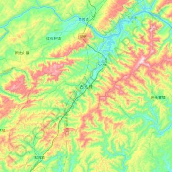
Nom : Carte topographique 古丈县, altitude, relief.
Lieu : 古丈县, 湘西土家族苗族自治州, 湖南省, 中国 (28.46062 109.78603 28.78062 110.10603)
Altitude moyenne : 508 m
Altitude minimum : 185 m
Altitude maximum : 1 118 m
武陵山脉斜贯全境,最高海拔1146米,最低海拔147米;主要河流为酉水。相邻的县级行政区,北接永顺,东临沅陵,南界泸溪和吉首,西部和花垣相连。
Autres cartes topographiques
Cliquez sur une carte pour visualiser sa topographie, son altitude et son relief.