
Faire un don
Équipez-vous pour votre prochaine aventure :
En tant que Partenaire Amazon, ce site perçoit une commission sur les achats éligibles sans surcoût pour vous.
Carte topographique Oak Hill
Cliquez sur la carte pour afficher l’altitude.
Faire un don
Équipez-vous pour votre prochaine aventure :
En tant que Partenaire Amazon, ce site perçoit une commission sur les achats éligibles sans surcoût pour vous.
À propos de cette carte
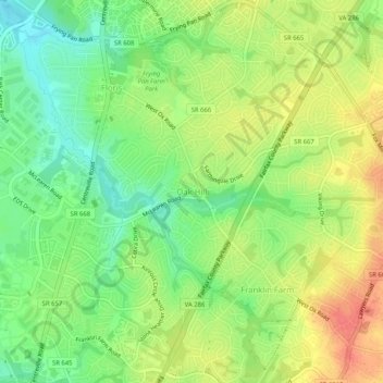
Nom : Carte topographique Oak Hill, altitude, relief.
Lieu : Oak Hill, Fairfax County, Virginia, 20171, United States (38.90597 -77.42192 38.94597 -77.38192)
Altitude moyenne : 111 m
Altitude minimum : 83 m
Altitude maximum : 141 m
Faire un don
Équipez-vous pour votre prochaine aventure :
En tant que Partenaire Amazon, ce site perçoit une commission sur les achats éligibles sans surcoût pour vous.
Autres cartes topographiques
Cliquez sur une carte pour visualiser sa topographie, son altitude et son relief.
Faire un don
Équipez-vous pour votre prochaine aventure :
En tant que Partenaire Amazon, ce site perçoit une commission sur les achats éligibles sans surcoût pour vous.
West Falls Church
United States > Virginia > Fairfax County > West Falls Church
Altitude moyenne : 97 m
Faire un don
Équipez-vous pour votre prochaine aventure :
En tant que Partenaire Amazon, ce site perçoit une commission sur les achats éligibles sans surcoût pour vous.
Lorton
United States > Virginia > Fairfax County > Lorton
According to the United States Census Bureau, the Lorton CDP has a total area of 5.4 square miles (13.9 km2), of which 5.3 square miles (13.7 km2) is land and 0.1 square miles (0.2 km2), or 1.39%, is water. The elevation ranges from sea level at the Prince William County line (the Occoquan River) to slightly…
Altitude moyenne : 37 m
Faire un don
Équipez-vous pour votre prochaine aventure :
En tant que Partenaire Amazon, ce site perçoit une commission sur les achats éligibles sans surcoût pour vous.
Vienna
United States > Virginia > Fairfax County
Vienna is located at 38°54′N 77°16′W / 38.900°N 77.267°W / 38.900; -77.267 (38.8991, −77.2607), at an elevation of 358 feet (109 meters). It lies in the Piedmont approximately 5.5 miles (8.9 km) southwest of the Potomac River. Wolftrap Creek, a tributary of nearby Difficult Run, flows north…
Altitude moyenne : 117 m
Faire un don
Équipez-vous pour votre prochaine aventure :
En tant que Partenaire Amazon, ce site perçoit une commission sur les achats éligibles sans surcoût pour vous.
Faire un don
Équipez-vous pour votre prochaine aventure :
En tant que Partenaire Amazon, ce site perçoit une commission sur les achats éligibles sans surcoût pour vous.
Faire un don
Équipez-vous pour votre prochaine aventure :
En tant que Partenaire Amazon, ce site perçoit une commission sur les achats éligibles sans surcoût pour vous.
Faire un don
Équipez-vous pour votre prochaine aventure :
En tant que Partenaire Amazon, ce site perçoit une commission sur les achats éligibles sans surcoût pour vous.
Faire un don
Équipez-vous pour votre prochaine aventure :
En tant que Partenaire Amazon, ce site perçoit une commission sur les achats éligibles sans surcoût pour vous.
Wolf Trap National Park for the Performing Arts
United States > Virginia > Fairfax County
Altitude moyenne : 104 m
McLean
United States > Virginia > Fairfax County > McLean
McLean is located at 38°56′03″N 77°10′39″W / 38.93417°N 77.17750°W / 38.93417; -77.17750 (38.9342776, -77.1774801) at an elevation of 285 feet (87 m). Located on the Capital Beltway (Interstate 495) in Northern Virginia, central McLean is 8 miles (13 km) northwest of downtown Washington,…
Altitude moyenne : 89 m
Faire un don
Équipez-vous pour votre prochaine aventure :
En tant que Partenaire Amazon, ce site perçoit une commission sur les achats éligibles sans surcoût pour vous.
Faire un don
Équipez-vous pour votre prochaine aventure :
En tant que Partenaire Amazon, ce site perçoit une commission sur les achats éligibles sans surcoût pour vous.
Faire un don
Équipez-vous pour votre prochaine aventure :
En tant que Partenaire Amazon, ce site perçoit une commission sur les achats éligibles sans surcoût pour vous.
Lorton
United States > Virginia > Fairfax County
According to the United States Census Bureau, the Lorton CDP has a total area of 5.4 square miles (13.9 km2), of which 5.3 square miles (13.7 km2) is land and 0.1 square miles (0.2 km2), or 1.39%, is water. The elevation ranges from sea level at the Prince William County line (the Occoquan River) to slightly…
Altitude moyenne : 41 m
Faire un don
Équipez-vous pour votre prochaine aventure :
En tant que Partenaire Amazon, ce site perçoit une commission sur les achats éligibles sans surcoût pour vous.
McLean
United States > Virginia > Fairfax County > McLean
McLean is located at 38°56′03″N 77°10′39″W / 38.93417°N 77.17750°W / 38.93417; -77.17750 (38.9342776, −77.1774801) at an elevation of 285 feet (87 m). Located on the Capital Beltway (Interstate 495) in Northern Virginia, central McLean is 8 miles (13 km) northwest of downtown Washington,…
Altitude moyenne : 89 m
Tysons
United States > Virginia > Fairfax County > Tysons
Tysons is located at 38°55′7″N 77°13′47″W / 38.91861°N 77.22972°W / 38.91861; -77.22972 (38.918485, −77.229833) at an elevation of 486 feet (148 m). Located in Northern Virginia at the intersection of Virginia State Route 123 and State Route 7, Tysons is 11 miles (18 km) west of downtown…
Altitude moyenne : 123 m
Faire un don
Équipez-vous pour votre prochaine aventure :
En tant que Partenaire Amazon, ce site perçoit une commission sur les achats éligibles sans surcoût pour vous.
Izaak Walton League of America - Arlington-Fairfax Chapter
United States > Virginia > Fairfax County > Centreville
Altitude moyenne : 72 m
Faire un don
Équipez-vous pour votre prochaine aventure :
En tant que Partenaire Amazon, ce site perçoit une commission sur les achats éligibles sans surcoût pour vous.
George Washington's Mount Vernon
United States > Virginia > Fairfax County > Mount Vernon
Visitors to Mount Vernon now see Washington's study, a room to which in the 18th century only a privileged few were granted entry. This simply furnished room has a combined bathroom, dressing room and office; the room was so private that few contemporary descriptions exist. Its walls are lined with naturally…
Altitude moyenne : 14 m
Faire un don
Équipez-vous pour votre prochaine aventure :
En tant que Partenaire Amazon, ce site perçoit une commission sur les achats éligibles sans surcoût pour vous.
Faire un don
Équipez-vous pour votre prochaine aventure :
En tant que Partenaire Amazon, ce site perçoit une commission sur les achats éligibles sans surcoût pour vous.
Faire un don
Équipez-vous pour votre prochaine aventure :
En tant que Partenaire Amazon, ce site perçoit une commission sur les achats éligibles sans surcoût pour vous.
Tysons
United States > Virginia > Fairfax County
Tysons is located at 38°55′7″N 77°13′47″W / 38.91861°N 77.22972°W / 38.91861; -77.22972 (38.918485, −77.229833) at an elevation of 486 feet (148 m). Located in Northern Virginia at the intersection of Virginia State Route 123 and State Route 7, Tysons is 11 miles (18 km) west of downtown…
Altitude moyenne : 122 m
Mount Vernon Community Park
United States > Virginia > Fairfax County > Fort Hunt > Snowden
Altitude moyenne : 14 m