
Faire un don
Équipez-vous pour votre prochaine aventure :
En tant que Partenaire Amazon, ce site perçoit une commission sur les achats éligibles sans surcoût pour vous.
Carte topographique Dalton
Cliquez sur la carte pour afficher l’altitude.
Faire un don
Équipez-vous pour votre prochaine aventure :
En tant que Partenaire Amazon, ce site perçoit une commission sur les achats éligibles sans surcoût pour vous.
À propos de cette carte
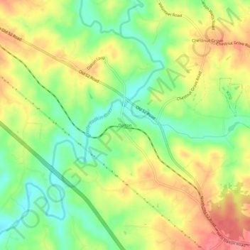
Nom : Carte topographique Dalton, altitude, relief.
Lieu : Dalton, Stokes County, North Carolina, United States (36.28903 -80.42117 36.32903 -80.38117)
Altitude moyenne : 287 m
Altitude minimum : 246 m
Altitude maximum : 330 m
Faire un don
Équipez-vous pour votre prochaine aventure :
En tant que Partenaire Amazon, ce site perçoit une commission sur les achats éligibles sans surcoût pour vous.
Autres cartes topographiques
Cliquez sur une carte pour visualiser sa topographie, son altitude et son relief.
Hanging Rock State Park
United States > North Carolina > Stokes County > Danbury
Hanging Rock State Park is located in the Sauratown Mountain Range, one of the most easterly mountain ranges in the state. Often called "the mountains away from the mountains," the Sauratown range is made up of monadnocks that are separated from the nearby Blue Ridge Mountains. The Sauratown Mountains lie…
Altitude moyenne : 323 m
Faire un don
Équipez-vous pour votre prochaine aventure :
En tant que Partenaire Amazon, ce site perçoit une commission sur les achats éligibles sans surcoût pour vous.