
Carte topographique Hingham Center
Carte interactive
Cliquez sur la carte pour afficher l’altitude.
À propos de cette carte
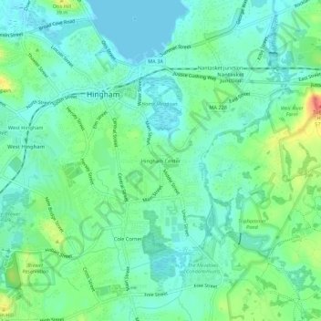
Nom : Carte topographique Hingham Center, altitude, relief.
Altitude moyenne : 17 m
Altitude minimum : -2 m
Altitude maximum : 60 m
Autres cartes topographiques
Cliquez sur une carte pour visualiser sa topographie, son altitude et son relief.
George Washington Forest
United States > Massachusetts > Plymouth County > Hingham > South Hingham
George Washington Forest, Huntley Road, South Hingham, Hingham, Plymouth County, Massachusetts, 02043, United States
Altitude moyenne : 37 m
Old Spain
United States > Massachusetts > Plymouth County > Hingham
Old Spain, Hingham, Plymouth County, Massachusetts, 02043, United States
Altitude moyenne : 11 m