
Faire un don
Équipez-vous pour votre prochaine aventure :
En tant que Partenaire Amazon, ce site perçoit une commission sur les achats éligibles sans surcoût pour vous.
Carte topographique Iraq Al-Amir
Cliquez sur la carte pour afficher l’altitude.
Faire un don
Équipez-vous pour votre prochaine aventure :
En tant que Partenaire Amazon, ce site perçoit une commission sur les achats éligibles sans surcoût pour vous.
Iraq Al-Amir
'Iraq al-Amir or Araq el-Amir (Arabic:عراق الأمير - literally, "Caves of the Prince"), is the name shared by a town and nearby caves, within the municipality of Amman in the Jordan Valley. Located about 15 km southwest of the town of Wadi as-Seer, it has a population of about 6000 people, mostly members of the Abbadi tribe. It is located on hills with high and medium altitude, in an area with many springs and famous for its olive trees and other forest trees.
Faire un don
Équipez-vous pour votre prochaine aventure :
En tant que Partenaire Amazon, ce site perçoit une commission sur les achats éligibles sans surcoût pour vous.
À propos de cette carte
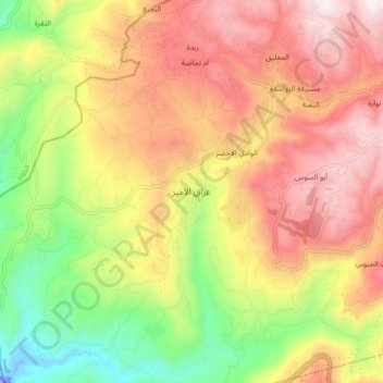
Nom : Carte topographique Iraq Al-Amir, altitude, relief.
Altitude moyenne : 487 m
Altitude minimum : -49 m
Altitude maximum : 932 m
Faire un don
Équipez-vous pour votre prochaine aventure :
En tant que Partenaire Amazon, ce site perçoit une commission sur les achats éligibles sans surcoût pour vous.
Autres cartes topographiques
Cliquez sur une carte pour visualiser sa topographie, son altitude et son relief.