
Faire un don
Équipez-vous pour votre prochaine aventure :
En tant que Partenaire Amazon, ce site perçoit une commission sur les achats éligibles sans surcoût pour vous.
Carte topographique Crystal Lake
Cliquez sur la carte pour afficher l’altitude.
Faire un don
Équipez-vous pour votre prochaine aventure :
En tant que Partenaire Amazon, ce site perçoit une commission sur les achats éligibles sans surcoût pour vous.
Crystal Lake
The CDP is home to Crystal Lake, a 187-acre (76 ha) lake that straddles the border between Ellington and Stafford. Most of the lake shore is occupied by private residences, but there is a small public beach called Sandy Beach on the south side of the lake. The lake has an average depth of 20 feet (6.1 m), a maximum depth of 50 feet (15 m) and an elevation of 637 feet (194 m).
Faire un don
Équipez-vous pour votre prochaine aventure :
En tant que Partenaire Amazon, ce site perçoit une commission sur les achats éligibles sans surcoût pour vous.
À propos de cette carte
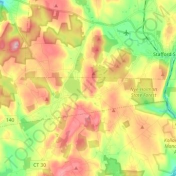
Nom : Carte topographique Crystal Lake, altitude, relief.
Altitude moyenne : 213 m
Altitude minimum : 113 m
Altitude maximum : 315 m
Faire un don
Équipez-vous pour votre prochaine aventure :
En tant que Partenaire Amazon, ce site perçoit une commission sur les achats éligibles sans surcoût pour vous.