
Carte topographique Gormanston
Cliquez sur la carte pour afficher l’altitude.
À propos de cette carte
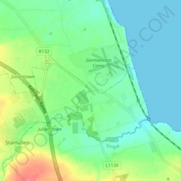
Nom : Carte topographique Gormanston, altitude, relief.
Altitude moyenne : 18 m
Altitude minimum : 0 m
Altitude maximum : 59 m
Autres cartes topographiques
Cliquez sur une carte pour visualiser sa topographie, son altitude et son relief.
Julianstown
Julianstown was the seat of the Moore family who lived in Julianstown House and occupied the land that now contains the townland of Julianstown West. Taylor and Skinner's 1783 Road Map of Ireland refers to the Moore seat and also shows the Church of Ireland church which still stands today. There is little…
Altitude moyenne : 20 m