
Carte topographique Sulby
Carte interactive
Cliquez sur la carte pour afficher l’altitude.
À propos de cette carte
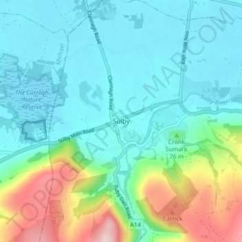
Nom : Carte topographique Sulby, altitude, relief.
Lieu : Sulby, Lezayre, Ayre, Isle of Man (54.29973 -4.50958 54.33973 -4.46958)
Altitude moyenne : 73 m
Altitude minimum : 4 m
Altitude maximum : 301 m
Autres cartes topographiques
Cliquez sur une carte pour visualiser sa topographie, son altitude et son relief.
Yellow Stone
Isle of Man > Ayre > Lezayre
Yellow Stone, Lezayre, Ayre, IM4 7NY, Isle of Man
Altitude moyenne : 407 m