
Faire un don
Équipez-vous pour votre prochaine aventure :
En tant que Partenaire Amazon, ce site perçoit une commission sur les achats éligibles sans surcoût pour vous.
Carte topographique Al Ismailiya
Cliquez sur la carte pour afficher l’altitude.
Faire un don
Équipez-vous pour votre prochaine aventure :
En tant que Partenaire Amazon, ce site perçoit une commission sur les achats éligibles sans surcoût pour vous.
À propos de cette carte
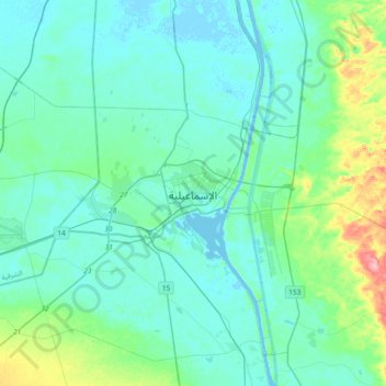
Nom : Carte topographique Al Ismailiya, altitude, relief.
Lieu : Al Ismailiya, 41544, Egypt (30.44438 32.11708 30.76438 32.43708)
Altitude moyenne : 21 m
Altitude minimum : -4 m
Altitude maximum : 142 m
Faire un don
Équipez-vous pour votre prochaine aventure :
En tant que Partenaire Amazon, ce site perçoit une commission sur les achats éligibles sans surcoût pour vous.
Autres cartes topographiques
Cliquez sur une carte pour visualiser sa topographie, son altitude et son relief.
Suez Canal
Although the alleged difference in sea levels could be problematic for construction, the idea of finding a shorter route to the east remained alive. In 1830, F. R. Chesney submitted a report to the British government that stated that there was no difference in elevation and that the Suez Canal was feasible,…
Altitude moyenne : 106 m
Suez Canal
Despite the construction challenges that could have been the result of the alleged difference in sea levels, the idea of finding a shorter route to the east remained alive. In 1830, General Francis Chesney submitted a report to the British government that stated that there was no difference in elevation and…
Altitude moyenne : 106 m