
Faire un don
Équipez-vous pour votre prochaine aventure :
En tant que Partenaire Amazon, ce site perçoit une commission sur les achats éligibles sans surcoût pour vous.
Carte topographique Ione
Cliquez sur la carte pour afficher l’altitude.
Faire un don
Équipez-vous pour votre prochaine aventure :
En tant que Partenaire Amazon, ce site perçoit une commission sur les achats éligibles sans surcoût pour vous.
Ione
Ione is situated on the west bank of the Pend Oreille River as it flows north towards Canada. Big Muddy Creek, Little Muddy Creek and Cedar Creek, from south to north, join the river in Ione. State Route 31 passes through town. Ione Bridge, on the southern edge of town, is the only road crossing of the Pend Oreille between Metaline Falls to the north and Usk to the south. Being located in the Selkirk Mountains, the area immediately surrounding Ione is of high topographic relief. The town itself is on a relatively flat area along the river at an elevation of 2,090 feet above sea level, but the mountains rise dramatically both sides of the Pend Oreille. Cement Mountain, with its peak roughly a mile immediately north of town, rises to 3,003 feet. Molybdenite Mountain, across the river from Ione, rises even higher to 6,788 feet.
Faire un don
Équipez-vous pour votre prochaine aventure :
En tant que Partenaire Amazon, ce site perçoit une commission sur les achats éligibles sans surcoût pour vous.
À propos de cette carte
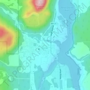
Nom : Carte topographique Ione, altitude, relief.
Altitude moyenne : 670 m
Altitude minimum : 614 m
Altitude maximum : 907 m
Faire un don
Équipez-vous pour votre prochaine aventure :
En tant que Partenaire Amazon, ce site perçoit une commission sur les achats éligibles sans surcoût pour vous.
Autres cartes topographiques
Cliquez sur une carte pour visualiser sa topographie, son altitude et son relief.
Faire un don
Équipez-vous pour votre prochaine aventure :
En tant que Partenaire Amazon, ce site perçoit une commission sur les achats éligibles sans surcoût pour vous.