
Carte topographique Tambunan
Carte interactive
Cliquez sur la carte pour afficher l’altitude.
À propos de cette carte
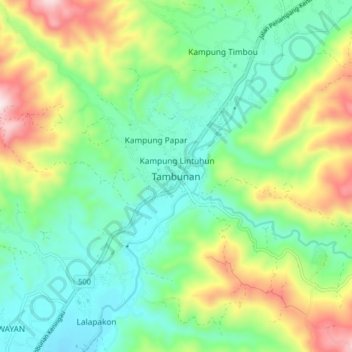
Nom : Carte topographique Tambunan, altitude, relief.
Lieu : Tambunan, Interior Division, Sabah, 89650, Malaysia (5.62880 116.32554 5.70880 116.40554)
Altitude moyenne : 697 m
Altitude minimum : 504 m
Altitude maximum : 1 108 m
Tambunan (Malay: Pekan Tambunan) is the capital of the Tambunan District in the Interior Division of Sabah, Malaysia. Its population was estimated to be around 35,667 in 2010. It is located 80 kilometres east of the state capital, Kota Kinabalu (to which is connected by the Kota Kinabalu-Tambunan-Keningau Highway), 48 kilometres south of Ranau and 48 kilometres north of Keningau. At an average altitude of 750 metres, this valley town, which is part of the Crocker Range, experiences a mild tropical climate all year long. The valley is peppered with terraced paddy fields and 70 villages. The dense forests of bamboo around Tambunan town are a legacy of the British colonial period, during which an edict stated that 20 bamboo sprouts had to be planted for every bamboo cut.
Autres cartes topographiques
Cliquez sur une carte pour visualiser sa topographie, son altitude et son relief.
Sinurambi Tower
Malaysia > Sabah > Tambunan > Tambunan
Sinurambi Tower, Jalan Kaingaran, Pekan Tambunan, Tambunan, Interior Division, Sabah, 89650, Malaysia
Altitude moyenne : 707 m
LOTONG ULU
LOTONG ULU, Tambunan, Interior Division, Sabah, Malaysia
Altitude moyenne : 563 m
Kampung Kituntul
Kampung Kituntul, Tambunan, Interior Division, Sabah, 89650, Malaysia
Altitude moyenne : 681 m