
Carte topographique Colachel
Carte interactive
Cliquez sur la carte pour afficher l’altitude.
À propos de cette carte
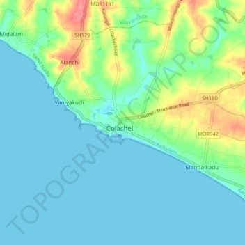
Nom : Carte topographique Colachel, altitude, relief.
Altitude moyenne : 16 m
Altitude minimum : -1 m
Altitude maximum : 72 m
The town is located on the western coastal side of Kanyakumari District and falls in the coordinates of 8°09′N 77°08′E / 8.15°N 77.14°E / 8.15; 77.14. The average elevation of the town is 25 meters (82 ft) above Mean Sea Level (MSL). Town is mostly characterized by a flat terrain with a few areas in the northwest region having elevation difference with other parts of the town. Generally the town is sloped gently from North to south direction and also sloping in a radial direction towards centre portion of the town from east and west directions.
Autres cartes topographiques
Cliquez sur une carte pour visualiser sa topographie, son altitude et son relief.
Kumarapuram
India > Tamil Nadu > Kalkulam
Kumarapuram, Kalkulam, Kanniyakumari District, Tamil Nadu, 629166, India
Altitude moyenne : 76 m
Aloor
India > Tamil Nadu > Kalkulam
Aloor, Kalkulam, Kanyakumari District, Tamil Nadu, 629809, India
Altitude moyenne : 41 m
Kalkulam
India > Tamil Nadu > Kalkulam
Kalkulam, Kanyakumari District, Tamil Nadu, India
Altitude moyenne : 245 m