
Carte topographique Guildford
Cliquez sur la carte pour afficher l’altitude.
À propos de cette carte
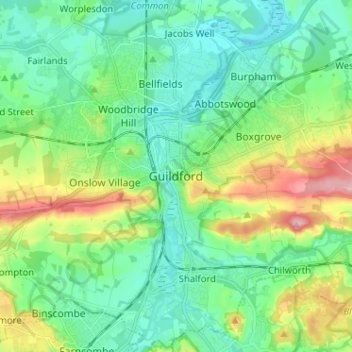
Nom : Carte topographique Guildford, altitude, relief.
Lieu : Guildford, Surrey, England, GU1 3DP, United Kingdom (51.19561 -0.61321 51.27561 -0.53321)
Altitude moyenne : 64 m
Altitude minimum : 22 m
Altitude maximum : 171 m
Autres cartes topographiques
Cliquez sur une carte pour visualiser sa topographie, son altitude et son relief.
Shalford
United Kingdom > England > Surrey > Guildford > Guildford
Lt.Col. Henry Haversham Godwin-Austen (1834–1923), topographer, geologist, naturalist and explorer who surveyed the Himalayan region, including K2, sometimes known as Mt. Godwin-Austen, for a time had an estate in Shalford.
Altitude moyenne : 54 m
Cranleigh Waters or Bramley Wey
United Kingdom > England > Surrey > Guildford > Shalford
Altitude moyenne : 52 m