
Carte topographique Springfield
Carte interactive
Cliquez sur la carte pour afficher l’altitude.
À propos de cette carte
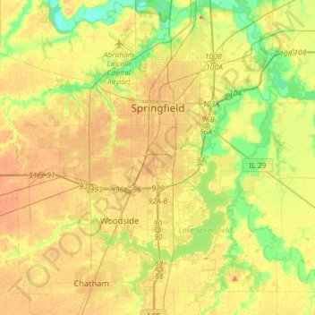
Nom : Carte topographique Springfield, altitude, relief.
Lieu : Springfield, Sangamon County, Illinois, United States (39.65366 -89.77318 39.87417 -89.56851)
Altitude moyenne : 178 m
Altitude minimum : 152 m
Altitude maximum : 201 m
The city is at an elevation of 558 feet (170 m) above sea level. According to the 2010 census, Springfield has a total area of 65.764 square miles (170.33 km2), of which 59.48 square miles (154.05 km2) (or 90.44%) is land and 6.284 square miles (16.28 km2) (or 9.56%) is water. The city is located in the Lower Illinois River Basin, in a large area known as Till Plain. Sangamon County, and the city of Springfield, are in the Springfield Plain subsection of Till Plain. The Plain is underlain by glacial till that was deposited by a large continental ice sheet that repeatedly covered the area during the Illinoian Stage.
Autres cartes topographiques
Cliquez sur une carte pour visualiser sa topographie, son altitude et son relief.
Williamsville
United States > Illinois > Sangamon County
Williamsville, Sangamon County, Illinois, 62693, United States
Altitude moyenne : 177 m
Archer
United States > Illinois > Sangamon County > Springfield
Archer, Springfield, Sangamon County, Illinois, 62711, United States
Altitude moyenne : 184 m
Spaulding
United States > Illinois > Sangamon County
Spaulding, Sangamon County, Illinois, United States
Altitude moyenne : 171 m
Pleasant Plains
United States > Illinois > Sangamon County
Pleasant Plains, Sangamon County, Illinois, United States
Altitude moyenne : 187 m