
Faire un don
Équipez-vous pour votre prochaine aventure :
En tant que Partenaire Amazon, ce site perçoit une commission sur les achats éligibles sans surcoût pour vous.
Carte topographique Port Jefferson Harbor
Cliquez sur la carte pour afficher l’altitude.
Faire un don
Équipez-vous pour votre prochaine aventure :
En tant que Partenaire Amazon, ce site perçoit une commission sur les achats éligibles sans surcoût pour vous.
À propos de cette carte
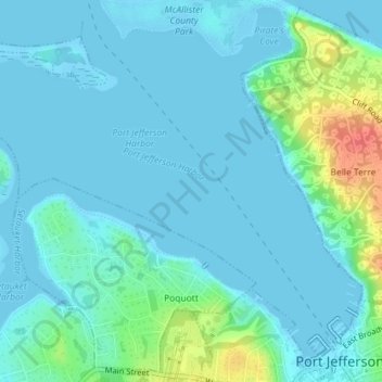
Nom : Carte topographique Port Jefferson Harbor, altitude, relief.
Altitude moyenne : 10 m
Altitude minimum : -4 m
Altitude maximum : 56 m
Faire un don
Équipez-vous pour votre prochaine aventure :
En tant que Partenaire Amazon, ce site perçoit une commission sur les achats éligibles sans surcoût pour vous.
Autres cartes topographiques
Cliquez sur une carte pour visualiser sa topographie, son altitude et son relief.
Stony Brook University
United States > New York > Suffolk County > Town of Brookhaven
Altitude moyenne : 46 m
Faire un don
Équipez-vous pour votre prochaine aventure :
En tant que Partenaire Amazon, ce site perçoit une commission sur les achats éligibles sans surcoût pour vous.
Village of Belle Terre
United States > New York > Suffolk County > Town of Brookhaven
Altitude moyenne : 20 m
Middle Island
United States > New York > Suffolk County > Town of Brookhaven
On October 27, 1910, the International Aviation Tournament was held at the Belmont Park racetrack in Elmont, New York. The meet offered $3,750 for the highest altitude, another $1,000 for a world record and a $5,000 bonus for exceeding 10,000 feet. Ralph Johnstone set a new American flight altitude record of…
Altitude moyenne : 31 m