
Carte topographique Claremont
Carte interactive
Cliquez sur la carte pour afficher l’altitude.
À propos de cette carte
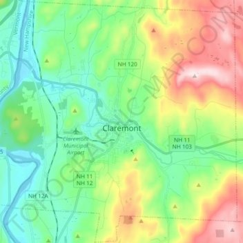
Nom : Carte topographique Claremont, altitude, relief.
Lieu : Claremont, Sullivan County, New Hampshire, United States (43.32202 -72.41617 43.42885 -72.26795)
Altitude moyenne : 236 m
Altitude minimum : 83 m
Altitude maximum : 599 m
The city is in western Sullivan County and is bordered to the west by the Connecticut River, the boundary between New Hampshire and Vermont. According to the United States Census Bureau, the city has a total area of 44.1 square miles (114.1 km2), of which 43.2 square miles (111.8 km2) are land and 0.89 square miles (2.3 km2) are water, comprising 2.04% of the town. The Sugar River flows from east to west through the center of Claremont, descending 150 feet (46 m) in elevation through the downtown, and empties into the Connecticut. The highest point in the city is the summit of Green Mountain, at 2,018 feet (615 m) above sea level in the northeastern part of the city. Claremont lies fully within the Connecticut River watershed.
Autres cartes topographiques
Cliquez sur une carte pour visualiser sa topographie, son altitude et son relief.
Washington
United States > New Hampshire > Sullivan County
Washington, Sullivan County, New Hampshire, 03280, United States
Altitude moyenne : 466 m
Sunapee
United States > New Hampshire > Sullivan County
Sunapee, Sullivan County, New Hampshire, United States
Altitude moyenne : 363 m
East Unity
United States > New Hampshire > Sullivan County > Unity
East Unity, Unity, Sullivan County, New Hampshire, United States
Altitude moyenne : 399 m
Croydon
United States > New Hampshire > Sullivan County
Croydon, Sullivan County, New Hampshire, United States
Altitude moyenne : 372 m
Newport
United States > New Hampshire > Sullivan County
Newport, Sullivan County, New Hampshire, United States
Altitude moyenne : 339 m
Ryder Corner
United States > New Hampshire > Sullivan County > Croydon
Ryder Corner, Croydon, Sullivan County, New Hampshire, 03754, United States
Altitude moyenne : 352 m
Grantham
United States > New Hampshire > Sullivan County
Grantham, Sullivan County, New Hampshire, 03753, United States
Altitude moyenne : 419 m
Unity
United States > New Hampshire > Sullivan County
Unity, Sullivan County, New Hampshire, United States
Altitude moyenne : 369 m
Green Mountain
United States > New Hampshire > Sullivan County > Claremont
Green Mountain, Claremont, Sullivan County, New Hampshire, United States
Altitude moyenne : 446 m
Goshen
United States > New Hampshire > Sullivan County > Goshen
Goshen, Sullivan County, New Hampshire, 03752, United States
Altitude moyenne : 419 m
Eastman
United States > New Hampshire > Sullivan County > Grantham > Eastman
Eastman, Grantham, Sullivan County, New Hampshire, 03753, United States
Altitude moyenne : 347 m
Acworth
United States > New Hampshire > Sullivan County
Acworth, Sullivan County, New Hampshire, 03601, United States
Altitude moyenne : 380 m
Langdon
United States > New Hampshire > Sullivan County
Langdon, Sullivan County, New Hampshire, United States
Altitude moyenne : 239 m
Mill Hollow
United States > New Hampshire > Sullivan County > Plainfield > Mill Hollow
Mill Hollow, Plainfield, Sullivan County, New Hampshire, 03770, United States
Altitude moyenne : 313 m
Lempster
United States > New Hampshire > Sullivan County
Lempster, Sullivan County, New Hampshire, 03605, United States
Altitude moyenne : 425 m
North Grantham
United States > New Hampshire > Sullivan County > Grantham > North Grantham
North Grantham, Grantham, Sullivan County, New Hampshire, 03753, United States
Altitude moyenne : 386 m
Charlestown
United States > New Hampshire > Sullivan County
Charlestown, Sullivan County, New Hampshire, 03603, United States
Altitude moyenne : 256 m
Plainfield
United States > New Hampshire > Sullivan County > Plainfield
Plainfield, Sullivan County, New Hampshire, United States
Altitude moyenne : 267 m
Cornish
United States > New Hampshire > Sullivan County
Cornish, Sullivan County, New Hampshire, United States
Altitude moyenne : 272 m