
Faire un don
Équipez-vous pour votre prochaine aventure :
En tant que Partenaire Amazon, ce site perçoit une commission sur les achats éligibles sans surcoût pour vous.
Carte topographique Middletown
Cliquez sur la carte pour afficher l’altitude.
Faire un don
Équipez-vous pour votre prochaine aventure :
En tant que Partenaire Amazon, ce site perçoit une commission sur les achats éligibles sans surcoût pour vous.
À propos de cette carte
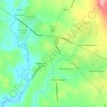
Nom : Carte topographique Middletown, altitude, relief.
Lieu : Middletown, Frederick County, Maryland, 21769, United States (39.42403 -77.56133 39.45160 -77.51376)
Altitude moyenne : 165 m
Altitude minimum : 114 m
Altitude maximum : 257 m
Faire un don
Équipez-vous pour votre prochaine aventure :
En tant que Partenaire Amazon, ce site perçoit une commission sur les achats éligibles sans surcoût pour vous.
Autres cartes topographiques
Cliquez sur une carte pour visualiser sa topographie, son altitude et son relief.
Highland
United States > Maryland > Frederick County
The majority of the downtown Highland district is situated within the 418-acre (169 ha) land grant named "Hickory Ridge". The Rouse Company borrowed the land grant name for one of its nearby villages of Columbia, built in 1974. The historic "White Hall" or "Hickory Ridge" estate (1749) was owned by the…
Altitude moyenne : 357 m
Faire un don
Équipez-vous pour votre prochaine aventure :
En tant que Partenaire Amazon, ce site perçoit une commission sur les achats éligibles sans surcoût pour vous.
Faire un don
Équipez-vous pour votre prochaine aventure :
En tant que Partenaire Amazon, ce site perçoit une commission sur les achats éligibles sans surcoût pour vous.
Catoctin Mountain
United States > Maryland > Frederick County
Catoctin Mountain traverses Frederick County, Maryland and extends into northern Loudoun County, Virginia. It rises to its greatest elevation of 1,900 feet (580 m) above sea level just southwest of Cunningham Falls State Park and is transected by gaps at Braddock Heights (Fairview Pass), Point of Rocks on the…
Altitude moyenne : 471 m
Faire un don
Équipez-vous pour votre prochaine aventure :
En tant que Partenaire Amazon, ce site perçoit une commission sur les achats éligibles sans surcoût pour vous.
Highland
United States > Maryland > Frederick County
The majority of the downtown Highland district is situated within the 418-acre (169 ha) land grant named "Hickory Ridge". The Rouse Company borrowed the land grant name for one of its nearby villages of Columbia, built in 1974. The historic "White Hall" or "Hickory Ridge" estate (1749) was owned by the…
Altitude moyenne : 357 m
Faire un don
Équipez-vous pour votre prochaine aventure :
En tant que Partenaire Amazon, ce site perçoit une commission sur les achats éligibles sans surcoût pour vous.
Faire un don
Équipez-vous pour votre prochaine aventure :
En tant que Partenaire Amazon, ce site perçoit une commission sur les achats éligibles sans surcoût pour vous.
West Frederick Highlands
United States > Maryland > Frederick County > Ballenger Creek
Altitude moyenne : 113 m
Faire un don
Équipez-vous pour votre prochaine aventure :
En tant que Partenaire Amazon, ce site perçoit une commission sur les achats éligibles sans surcoût pour vous.
Colonial Heights
United States > Maryland > Frederick County > Thurmont > Colonial Heights
Altitude moyenne : 157 m
Faire un don
Équipez-vous pour votre prochaine aventure :
En tant que Partenaire Amazon, ce site perçoit une commission sur les achats éligibles sans surcoût pour vous.
Mount Airy Estates
United States > Maryland > Frederick County > Mount Airy Estates
Altitude moyenne : 161 m
Faire un don
Équipez-vous pour votre prochaine aventure :
En tant que Partenaire Amazon, ce site perçoit une commission sur les achats éligibles sans surcoût pour vous.