
Faire un don
Équipez-vous pour votre prochaine aventure :
En tant que Partenaire Amazon, ce site perçoit une commission sur les achats éligibles sans surcoût pour vous.
Carte topographique McCall
Cliquez sur la carte pour afficher l’altitude.
Faire un don
Équipez-vous pour votre prochaine aventure :
En tant que Partenaire Amazon, ce site perçoit une commission sur les achats éligibles sans surcoût pour vous.
McCall
Brundage Mountain, northwest of McCall, opened in November 1961. Brundage has a summit elevation of 7,803 feet (2,380 m) above sea level, and a vertical drop of 1,921 feet (590 m). The slopes on Brundage Mountain are primarily west-facing and the mountain's average snowfall exceeds 320 inches (810 cm). It currently has five chairlifts and one Magic Carpet (two high-speed quad chairs, three triple chairs, and one magic carpet) with a capacity of 9,000 people per hour. The lifts afford access to 1920 acres of terrain, including 420 acres of lift-accessed, un-patrolled, without avalanche mitigation, backcountry terrain. The resort also operates a backcountry snowcat skiing operation which provides guided access to 18,000 acres (73 km2) of untracked powder in the Payette National Forest north of the ski area. There are also three terrain parks of varying difficulty. Summer activities include lift-served mountain biking trails, scenic chairlift rides, summer concerts, yoga and other calendared events. Brundage was owned by the DeBoer family, descendants of early McCall pioneers, with J. R. Simplot. In April 2016, the DeBoers took full control of the property, purchasing the 50% interest of the his family. In 2020, ownership was transferred to Brundage Mountain Holdings with the DeBoer family maintaining an ownership stake.
Faire un don
Équipez-vous pour votre prochaine aventure :
En tant que Partenaire Amazon, ce site perçoit une commission sur les achats éligibles sans surcoût pour vous.
À propos de cette carte
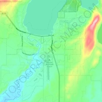
Nom : Carte topographique McCall, altitude, relief.
Lieu : McCall, Valley County, Idaho, 83638, United States (44.86605 -116.16411 44.93408 -116.06501)
Altitude moyenne : 1 546 m
Altitude minimum : 1 491 m
Altitude maximum : 1 703 m
Faire un don
Équipez-vous pour votre prochaine aventure :
En tant que Partenaire Amazon, ce site perçoit une commission sur les achats éligibles sans surcoût pour vous.
Autres cartes topographiques
Cliquez sur une carte pour visualiser sa topographie, son altitude et son relief.
Faire un don
Équipez-vous pour votre prochaine aventure :
En tant que Partenaire Amazon, ce site perçoit une commission sur les achats éligibles sans surcoût pour vous.
Faire un don
Équipez-vous pour votre prochaine aventure :
En tant que Partenaire Amazon, ce site perçoit une commission sur les achats éligibles sans surcoût pour vous.