
Carte topographique Johnson City
Carte interactive
Cliquez sur la carte pour afficher l’altitude.
À propos de cette carte
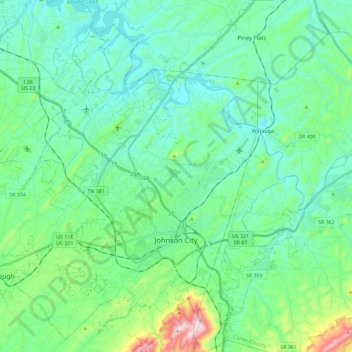
Nom : Carte topographique Johnson City, altitude, relief.
Altitude moyenne : 513 m
Altitude minimum : 399 m
Altitude maximum : 975 m
The steep mountains, rolling hills, and valleys surrounding the region are part of the Appalachian Ridge-and-Valley Province, and Johnson City is just west of the Blue Ridge Mountains. Roan Mountain, with an elevation of over 6,000 feet (1,800 m), is approximately 20 miles (32 km) to the southeast of the city. Buffalo Mountain, a ridge over 2,700 feet (820 m) high, is the location of a city park on the south side of town. The Watauga River arm of Boone Lake, a Tennessee Valley Authority reservoir, is partly within the city limits. The Nolichucky River flows 12 miles (19 km) to the south of Johnson City. Whitewater rafting and kayaking opportunities exist 20 miles (32 km) south of Johnson City where that river flows from the North Carolina state line near Erwin.
Autres cartes topographiques
Cliquez sur une carte pour visualiser sa topographie, son altitude et son relief.
Dogwood Acres
United States > Tennessee > Washington County > Johnson City
Dogwood Acres, Johnson City, Washington County, East Tennessee, Tennessee, 37684, United States
Altitude moyenne : 550 m
El Rancho
United States > Tennessee > Washington County > Johnson City
El Rancho, Johnson City, Washington County, East Tennessee, Tennessee, United States
Altitude moyenne : 469 m
Jonesborough
United States > Tennessee > Washington County
Jonesborough, Washington County, East Tennessee, Tennessee, 37659, United States
Altitude moyenne : 543 m
Buffalo Mountain
United States > Tennessee > Washington County
Buffalo Mountain, Washington County, Tennessee, 37684, United States
Altitude moyenne : 780 m
East Ridge
United States > Tennessee > Washington County > Johnson City > East Ridge
East Ridge, Johnson City, Washington County, Tennessee, 37601, United States
Altitude moyenne : 509 m
Carnegie
United States > Tennessee > Washington County > Johnson City > Carnegie
Carnegie, Johnson City, Washington County, Tennessee, 37601, United States
Altitude moyenne : 505 m
Johnson City
United States > Tennessee > Washington County > Johnson City
Johnson City, Washington County, Tennessee, 37614, United States
Altitude moyenne : 583 m