
Carte topographique Helvellyn
Cliquez sur la carte pour afficher l’altitude.
Helvellyn
Red Tarn, a classic corrie tarn, is a high-elevation tarn with low nutrient levels and poor in the number of species it supports. Characteristic vegetation zones include a water-starwort (Callitriche) in shallower areas and the alga Nitella flexilis in deeper water and around the inlet. Other species include a pondweed (Potamogeton) which grows in 2–3 m (7–10 ft) of water and the rush Juncus bulbosus. Brown trout and schelly, a species of whitefish, are found in the tarn.
À propos de cette carte
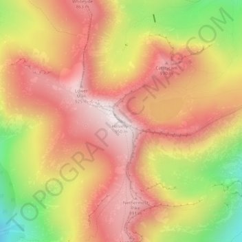
Nom : Carte topographique Helvellyn, altitude, relief.
Altitude moyenne : 680 m
Altitude minimum : 277 m
Altitude maximum : 943 m
Autres cartes topographiques
Cliquez sur une carte pour visualiser sa topographie, son altitude et son relief.
Brown Cove Tarn
United Kingdom > England > Westmorland and Furness > Patterdale
Altitude moyenne : 699 m
Brothers Water
United Kingdom > England > Westmorland and Furness > Patterdale > Hartsop
Altitude moyenne : 298 m