
Carte topographique Юрьева Горка
Carte interactive
Cliquez sur la carte pour afficher l’altitude.
À propos de cette carte
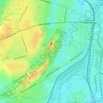
Nom : Carte topographique Юрьева Горка, altitude, relief.
Lieu : Юрьева Горка, Витебск, Витебская область, 210021, Беларусь (55.19104 30.16670 55.19114 30.16680)
Altitude moyenne : 157 m
Altitude minimum : 139 m
Altitude maximum : 187 m
Autres cartes topographiques
Cliquez sur une carte pour visualiser sa topographie, son altitude et son relief.
сквер имени Миная Шмырёва
Беларусь > Витебская область > Витебск
сквер имени Миная Шмырёва, Лучёса, Первомайский район, Витебск, Витебская область, Беларусь
Altitude moyenne : 160 m