
Faire un don
Équipez-vous pour votre prochaine aventure :
En tant que Partenaire Amazon, ce site perçoit une commission sur les achats éligibles sans surcoût pour vous.
Carte topographique Poe Valley State Park
Cliquez sur la carte pour afficher l’altitude.
Faire un don
Équipez-vous pour votre prochaine aventure :
En tant que Partenaire Amazon, ce site perçoit une commission sur les achats éligibles sans surcoût pour vous.
À propos de cette carte
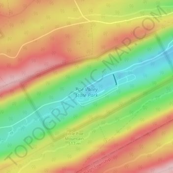
Nom : Carte topographique Poe Valley State Park, altitude, relief.
Altitude moyenne : 501 m
Altitude minimum : 383 m
Altitude maximum : 611 m
Faire un don
Équipez-vous pour votre prochaine aventure :
En tant que Partenaire Amazon, ce site perçoit une commission sur les achats éligibles sans surcoût pour vous.
Autres cartes topographiques
Cliquez sur une carte pour visualiser sa topographie, son altitude et son relief.
State College
United States > Pennsylvania > Centre County
State College is situated at an elevation of approximately 1,200 feet (370 m) above sea level. According to the U.S. Census Bureau, the borough has a total area of 4.5 square miles (12 km2), all of it land. It is surrounded by large tracts of farmland, and an expanse of Appalachian Mountain ranges and forests.…
Altitude moyenne : 351 m
Faire un don
Équipez-vous pour votre prochaine aventure :
En tant que Partenaire Amazon, ce site perçoit une commission sur les achats éligibles sans surcoût pour vous.
Black Moshannon State Park
United States > Pennsylvania > Centre County > Rush Township
Black Moshannon State Park is open year-round for recreation and has an extensive network of trails which allow hiking, biking, and viewing the bog habitat at the Black Moshannon State Natural Area. The park is in a Pennsylvania Important Bird Area, where bird watchers have recorded 175 species. It is also…
Altitude moyenne : 602 m
Faire un don
Équipez-vous pour votre prochaine aventure :
En tant que Partenaire Amazon, ce site perçoit une commission sur les achats éligibles sans surcoût pour vous.
Ramblewood
United States > Pennsylvania > Centre County > Ferguson Township > The Meadows
Altitude moyenne : 396 m
Park Forest Village
United States > Pennsylvania > Centre County > Ferguson Township
Altitude moyenne : 387 m
Pleasant Gap
United States > Pennsylvania > Centre County > Spring Township > Pleasant Gap
Altitude moyenne : 327 m
Faire un don
Équipez-vous pour votre prochaine aventure :
En tant que Partenaire Amazon, ce site perçoit une commission sur les achats éligibles sans surcoût pour vous.
Faire un don
Équipez-vous pour votre prochaine aventure :
En tant que Partenaire Amazon, ce site perçoit une commission sur les achats éligibles sans surcoût pour vous.
Houserville
United States > Pennsylvania > Centre County > College Township > Houserville
Altitude moyenne : 315 m
State College
United States > Pennsylvania > Centre County
State College is situated at an elevation of approximately 1,200 feet (370 m) above sea level. According to the U.S. Census Bureau, the borough has a total area of 4.5 square miles (12 km2), all of it land. It is surrounded by large tracts of farmland, and an expanse of Appalachian Mountain ranges and forests.…
Altitude moyenne : 351 m
Woodward
United States > Pennsylvania > Centre County > Haines Township > Woodward
Altitude moyenne : 447 m
Boalsburg
United States > Pennsylvania > Centre County > Harris Township > Boalsburg
Altitude moyenne : 426 m
Faire un don
Équipez-vous pour votre prochaine aventure :
En tant que Partenaire Amazon, ce site perçoit une commission sur les achats éligibles sans surcoût pour vous.
Faire un don
Équipez-vous pour votre prochaine aventure :
En tant que Partenaire Amazon, ce site perçoit une commission sur les achats éligibles sans surcoût pour vous.
Woodward
United States > Pennsylvania > Centre County > Haines Township > Woodward
Altitude moyenne : 447 m
Faire un don
Équipez-vous pour votre prochaine aventure :
En tant que Partenaire Amazon, ce site perçoit une commission sur les achats éligibles sans surcoût pour vous.
State College
United States > Pennsylvania > Centre County
Weather in State College is strongly influenced by the mountain and valley topology of the area. The surrounding mountains cause significantly lower temperatures in the winter, and make summer heat waves much rarer than in the rest of the state. Precipitation is about 20% lower than areas at comparable…
Altitude moyenne : 351 m
Faire un don
Équipez-vous pour votre prochaine aventure :
En tant que Partenaire Amazon, ce site perçoit une commission sur les achats éligibles sans surcoût pour vous.
Loch Lomond Junction
United States > Pennsylvania > Centre County > Rush Township
Altitude moyenne : 460 m
Faire un don
Équipez-vous pour votre prochaine aventure :
En tant que Partenaire Amazon, ce site perçoit une commission sur les achats éligibles sans surcoût pour vous.
State College
United States > Pennsylvania > Centre County
Weather in State College is strongly influenced by the mountain and valley topology of the area. The surrounding mountains cause significantly lower temperatures in the winter, and make summer heat waves much rarer than in the rest of the state. Precipitation is about 20% lower than areas at comparable…
Altitude moyenne : 351 m
Bald Eagle State Park
United States > Pennsylvania > Centre County > Howard Township
Foster Joseph Sayers Reservoir is a 1,730-acre (700 ha) reservoir that was built in 1971 by the U.S. Army Corps of Engineers as part of a flood control project on the Susquehanna River basin. The lake was created by damming Bald Eagle Creek. It stretches upstream for 8 miles (12.87 km) and has 23 miles (37.01…
Altitude moyenne : 290 m