
Faire un don
Équipez-vous pour votre prochaine aventure :
En tant que Partenaire Amazon, ce site perçoit une commission sur les achats éligibles sans surcoût pour vous.
Carte topographique Mount Angel
Cliquez sur la carte pour afficher l’altitude.
Faire un don
Équipez-vous pour votre prochaine aventure :
En tant que Partenaire Amazon, ce site perçoit une commission sur les achats éligibles sans surcoût pour vous.
Mount Angel
Rev. Fr. Adelhelm Odermatt, O.S.B., came to Oregon in 1881 with a contingent of Benedictine monks from Engelberg, Switzerland, in order to establish a new American daughter house. After visiting several locations, he found Lone Butte to be the ideal location for a new abbey, and shortly afterwards ministered to several local Roman Catholic parishes, about the same time large numbers of immigrants from Bavaria settled in the area. Due to his efforts, the city, post office and the nearby elevation Lone Butte came to be known as Mount Angel (an English translation of Engelberg) in 1883. He also established Mount Angel Abbey, a Benedictine monastery and school, which was moved permanently to Mt. Angel in 1884.
Faire un don
Équipez-vous pour votre prochaine aventure :
En tant que Partenaire Amazon, ce site perçoit une commission sur les achats éligibles sans surcoût pour vous.
À propos de cette carte
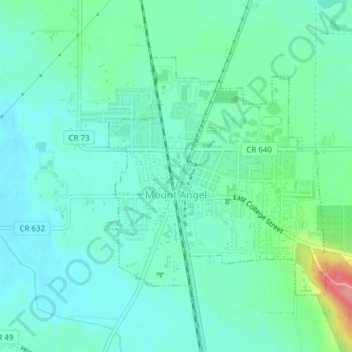
Nom : Carte topographique Mount Angel, altitude, relief.
Lieu : Mount Angel, Marion County, Oregon, United States (45.06008 -122.80715 45.07834 -122.78338)
Altitude moyenne : 58 m
Altitude minimum : 36 m
Altitude maximum : 134 m
Faire un don
Équipez-vous pour votre prochaine aventure :
En tant que Partenaire Amazon, ce site perçoit une commission sur les achats éligibles sans surcoût pour vous.