
Faire un don
Équipez-vous pour votre prochaine aventure :
En tant que Partenaire Amazon, ce site perçoit une commission sur les achats éligibles sans surcoût pour vous.
Carte topographique Leicestershire
Cliquez sur la carte pour afficher l’altitude.
Faire un don
Équipez-vous pour votre prochaine aventure :
En tant que Partenaire Amazon, ce site perçoit une commission sur les achats éligibles sans surcoût pour vous.
Leicestershire
A large part of the north-west of the county, around Coalville, forms part of the new National Forest area extending into Derbyshire and Staffordshire. The highest point of the county is Bardon Hill at 278 m (912 ft), which is also a Marilyn; with other hilly/upland areas of c. 150–200 metres (490–660 ft) and above in nearby Charnwood Forest and also to the east of the county around Launde Abbey. The lowest point, at an altitude of about 20 metres (66 ft), is located at the county's northernmost tip close to Bottesford where the River Devon flowing through the Vale of Belvoir leaves Leicestershire and enters Nottinghamshire. This results in an altitude differential (AΔ|vertical) of around 257.5 metres (845 ft) and a mean altitude of 148.75 metres (488.0 ft).
Faire un don
Équipez-vous pour votre prochaine aventure :
En tant que Partenaire Amazon, ce site perçoit une commission sur les achats éligibles sans surcoût pour vous.
À propos de cette carte
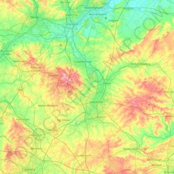
Nom : Carte topographique Leicestershire, altitude, relief.
Lieu : Leicestershire, England, United Kingdom (52.39217 -1.59755 52.97766 -0.66411)
Altitude moyenne : 98 m
Altitude minimum : 16 m
Altitude maximum : 269 m
Faire un don
Équipez-vous pour votre prochaine aventure :
En tant que Partenaire Amazon, ce site perçoit une commission sur les achats éligibles sans surcoût pour vous.
Autres cartes topographiques
Cliquez sur une carte pour visualiser sa topographie, son altitude et son relief.
Bradgate Park
United Kingdom > England > Leicestershire > Charnwood > Newtown Linford
Overlying the Beacon Hill Formation, but found a little further down the hillside to the south, are the Bradgate Formation beds, the most notable of which is the Sliding Stone Slump Breccia rocks. Forming a line of crags below Old John, these are laminated mudstones, with layers of sandstone, mainly of…
Altitude moyenne : 126 m
Lockington
United Kingdom > England > Leicestershire > North West Leicestershire
Altitude moyenne : 47 m
Faire un don
Équipez-vous pour votre prochaine aventure :
En tant que Partenaire Amazon, ce site perçoit une commission sur les achats éligibles sans surcoût pour vous.
Faire un don
Équipez-vous pour votre prochaine aventure :
En tant que Partenaire Amazon, ce site perçoit une commission sur les achats éligibles sans surcoût pour vous.
Kelham Bridge Nature Reserve
United Kingdom > England > Leicestershire > North West Leicestershire > Ravenstone
Altitude moyenne : 139 m
Market Bosworth Country Park
United Kingdom > England > Leicestershire > Hinckley and Bosworth > Market Bosworth
Altitude moyenne : 119 m
Faire un don
Équipez-vous pour votre prochaine aventure :
En tant que Partenaire Amazon, ce site perçoit une commission sur les achats éligibles sans surcoût pour vous.
Coalville
United Kingdom > England > Leicestershire > North West Leicestershire
Altitude moyenne : 149 m
Faire un don
Équipez-vous pour votre prochaine aventure :
En tant que Partenaire Amazon, ce site perçoit une commission sur les achats éligibles sans surcoût pour vous.
Faire un don
Équipez-vous pour votre prochaine aventure :
En tant que Partenaire Amazon, ce site perçoit une commission sur les achats éligibles sans surcoût pour vous.
Isley Walton
United Kingdom > England > Leicestershire > North West Leicestershire
Altitude moyenne : 76 m
Watermead Country Park
United Kingdom > England > Leicestershire > Charnwood > Birstall
Altitude moyenne : 59 m
Faire un don
Équipez-vous pour votre prochaine aventure :
En tant que Partenaire Amazon, ce site perçoit une commission sur les achats éligibles sans surcoût pour vous.
Ratcliffe Culey
United Kingdom > England > Leicestershire > Hinckley and Bosworth
Altitude moyenne : 77 m
Faire un don
Équipez-vous pour votre prochaine aventure :
En tant que Partenaire Amazon, ce site perçoit une commission sur les achats éligibles sans surcoût pour vous.
Brocks Hill
United Kingdom > England > Leicestershire > Oadby and Wigston > Oadby
Altitude moyenne : 102 m
Thringstone
United Kingdom > England > Leicestershire > North West Leicestershire
Altitude moyenne : 126 m
Adrian's Spinney
United Kingdom > England > Leicestershire > Harborough > Stoughton
Altitude moyenne : 113 m
Faire un don
Équipez-vous pour votre prochaine aventure :
En tant que Partenaire Amazon, ce site perçoit une commission sur les achats éligibles sans surcoût pour vous.
Faire un don
Équipez-vous pour votre prochaine aventure :
En tant que Partenaire Amazon, ce site perçoit une commission sur les achats éligibles sans surcoût pour vous.
Langham Brook
United Kingdom > England > Leicestershire > Melton > Saxby > Freeby
Altitude moyenne : 94 m
Lount Wood
United Kingdom > England > Leicestershire > North West Leicestershire > Lount
Altitude moyenne : 131 m
Faire un don
Équipez-vous pour votre prochaine aventure :
En tant que Partenaire Amazon, ce site perçoit une commission sur les achats éligibles sans surcoût pour vous.
Stretton Baskerville
United Kingdom > England > Leicestershire > Hinckley and Bosworth
Altitude moyenne : 111 m
Breedon on the Hill
United Kingdom > England > Leicestershire > North West Leicestershire
Altitude moyenne : 84 m
Faire un don
Équipez-vous pour votre prochaine aventure :
En tant que Partenaire Amazon, ce site perçoit une commission sur les achats éligibles sans surcoût pour vous.
Ravenstone
United Kingdom > England > Leicestershire > North West Leicestershire
Altitude moyenne : 143 m
Nailstone Colliery Railway
United Kingdom > England > Leicestershire > North West Leicestershire > Ibstock
Altitude moyenne : 155 m
Faire un don
Équipez-vous pour votre prochaine aventure :
En tant que Partenaire Amazon, ce site perçoit une commission sur les achats éligibles sans surcoût pour vous.
Fenny Drayton
United Kingdom > England > Leicestershire > Hinckley and Bosworth
Altitude moyenne : 86 m
Long Whatton
United Kingdom > England > Leicestershire > North West Leicestershire
Altitude moyenne : 63 m
Barton in the Beans
United Kingdom > England > Leicestershire > Hinckley and Bosworth
Altitude moyenne : 113 m
Faire un don
Équipez-vous pour votre prochaine aventure :
En tant que Partenaire Amazon, ce site perçoit une commission sur les achats éligibles sans surcoût pour vous.
Higham on the Hill
United Kingdom > England > Leicestershire > Hinckley and Bosworth
Altitude moyenne : 96 m
Timberwood Hill
United Kingdom > England > Leicestershire > North West Leicestershire
Altitude moyenne : 192 m
Breedon Cloud Wood
United Kingdom > England > Leicestershire > North West Leicestershire > Breedon on the Hill
Altitude moyenne : 90 m
Faire un don
Équipez-vous pour votre prochaine aventure :
En tant que Partenaire Amazon, ce site perçoit une commission sur les achats éligibles sans surcoût pour vous.
Faire un don
Équipez-vous pour votre prochaine aventure :
En tant que Partenaire Amazon, ce site perçoit une commission sur les achats éligibles sans surcoût pour vous.
Swannymote Rock
United Kingdom > England > Leicestershire > North West Leicestershire > Coalville
Altitude moyenne : 139 m
Willesley Woods
United Kingdom > England > Leicestershire > North West Leicestershire > Ashby-de-la-Zouch > Willesley
Altitude moyenne : 108 m
Faire un don
Équipez-vous pour votre prochaine aventure :
En tant que Partenaire Amazon, ce site perçoit une commission sur les achats éligibles sans surcoût pour vous.
Merry Lees
United Kingdom > England > Leicestershire > Hinckley and Bosworth > Botcheston
Altitude moyenne : 126 m
Kilby Bridge
United Kingdom > England > Leicestershire > Oadby and Wigston > Wigston
Altitude moyenne : 89 m
Moat Hill Spinney
United Kingdom > England > Leicestershire > Charnwood > Cotes
Altitude moyenne : 50 m
Faire un don
Équipez-vous pour votre prochaine aventure :
En tant que Partenaire Amazon, ce site perçoit une commission sur les achats éligibles sans surcoût pour vous.
Lea Wood
United Kingdom > England > Leicestershire > Charnwood > Newtown Linford
Altitude moyenne : 170 m
Faire un don
Équipez-vous pour votre prochaine aventure :
En tant que Partenaire Amazon, ce site perçoit une commission sur les achats éligibles sans surcoût pour vous.
Kegworth
United Kingdom > England > Leicestershire > North West Leicestershire
Altitude moyenne : 47 m
Faire un don
Équipez-vous pour votre prochaine aventure :
En tant que Partenaire Amazon, ce site perçoit une commission sur les achats éligibles sans surcoût pour vous.
Faire un don
Équipez-vous pour votre prochaine aventure :
En tant que Partenaire Amazon, ce site perçoit une commission sur les achats éligibles sans surcoût pour vous.
New Lubbesthorpe
United Kingdom > England > Leicestershire > Leicester Forest East
Altitude moyenne : 95 m
Faire un don
Équipez-vous pour votre prochaine aventure :
En tant que Partenaire Amazon, ce site perçoit une commission sur les achats éligibles sans surcoût pour vous.
Faire un don
Équipez-vous pour votre prochaine aventure :
En tant que Partenaire Amazon, ce site perçoit une commission sur les achats éligibles sans surcoût pour vous.
Diseworth
United Kingdom > England > Leicestershire > North West Leicestershire
Altitude moyenne : 77 m
Old John
United Kingdom > England > Leicestershire > Charnwood > Newtown Linford
Altitude moyenne : 143 m
Faire un don
Équipez-vous pour votre prochaine aventure :
En tant que Partenaire Amazon, ce site perçoit une commission sur les achats éligibles sans surcoût pour vous.
Kirkby Mallory
United Kingdom > England > Leicestershire > Hinckley and Bosworth
Altitude moyenne : 115 m
Faire un don
Équipez-vous pour votre prochaine aventure :
En tant que Partenaire Amazon, ce site perçoit une commission sur les achats éligibles sans surcoût pour vous.
Six Hills
United Kingdom > England > Leicestershire > Charnwood > Burton on the Wolds
Altitude moyenne : 128 m
Faire un don
Équipez-vous pour votre prochaine aventure :
En tant que Partenaire Amazon, ce site perçoit une commission sur les achats éligibles sans surcoût pour vous.