
Faire un don
Équipez-vous pour votre prochaine aventure :
En tant que Partenaire Amazon, ce site perçoit une commission sur les achats éligibles sans surcoût pour vous.
Carte topographique Falmouth
Cliquez sur la carte pour afficher l’altitude.
Faire un don
Équipez-vous pour votre prochaine aventure :
En tant que Partenaire Amazon, ce site perçoit une commission sur les achats éligibles sans surcoût pour vous.
Falmouth
Falmouth's topography is similar to the rest of Cape Cod's, with many small ponds, creeks, and inlets surrounded by the pines and oaks of the Cape and often rocky beachfront. Falmouth's southern shore is notable for a series of ponds and rivers spaced very closely together, all of which travel some distance into the town. These include, from west to east, Falmouth Inner Harbor, Little Pond, Great Pond (which leads to the Dexter and Coonamesset rivers), Green Pond, Bourne's Pond, Eel Pond (which leads to the Childs River), and Waquoit Bay, which lies along the Mashpee town line. The Buzzards Bay side of the town is primarily bays divided by necks, peninsulas connected to land by isthmi. The largest inlet is Megansett Cove along the Bourne town line. The Buzzards Bay shore of Falmouth is punctuated by a number of hamlets, including, from north to south, Megansett, New Silver Beach, Old Silver, Chappaquoit, Sippewisset, Quissett, and Woods Hole.
Faire un don
Équipez-vous pour votre prochaine aventure :
En tant que Partenaire Amazon, ce site perçoit une commission sur les achats éligibles sans surcoût pour vous.
À propos de cette carte
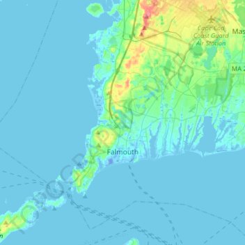
Nom : Carte topographique Falmouth, altitude, relief.
Lieu : Falmouth, Barnstable County, Massachusetts, United States (41.48914 -70.76063 41.66039 -70.49800)
Altitude moyenne : 7 m
Altitude minimum : -19 m
Altitude maximum : 72 m
Faire un don
Équipez-vous pour votre prochaine aventure :
En tant que Partenaire Amazon, ce site perçoit une commission sur les achats éligibles sans surcoût pour vous.
Autres cartes topographiques
Cliquez sur une carte pour visualiser sa topographie, son altitude et son relief.
Opeechee Heights Beach
United States > Massachusetts > Barnstable County > Barnstable > Centerville
Altitude moyenne : 14 m
Faire un don
Équipez-vous pour votre prochaine aventure :
En tant que Partenaire Amazon, ce site perçoit une commission sur les achats éligibles sans surcoût pour vous.
Faire un don
Équipez-vous pour votre prochaine aventure :
En tant que Partenaire Amazon, ce site perçoit une commission sur les achats éligibles sans surcoût pour vous.
Bourne Corners
United States > Massachusetts > Barnstable County > Bourne > Buzzards Bay
Altitude moyenne : 9 m
Gray Gables
United States > Massachusetts > Barnstable County > Bourne > Buzzards Bay
Altitude moyenne : 5 m
Faire un don
Équipez-vous pour votre prochaine aventure :
En tant que Partenaire Amazon, ce site perçoit une commission sur les achats éligibles sans surcoût pour vous.
Faire un don
Équipez-vous pour votre prochaine aventure :
En tant que Partenaire Amazon, ce site perçoit une commission sur les achats éligibles sans surcoût pour vous.
West Barnstable
United States > Massachusetts > Barnstable County > West Barnstable
Altitude moyenne : 15 m
Faire un don
Équipez-vous pour votre prochaine aventure :
En tant que Partenaire Amazon, ce site perçoit une commission sur les achats éligibles sans surcoût pour vous.
Faire un don
Équipez-vous pour votre prochaine aventure :
En tant que Partenaire Amazon, ce site perçoit une commission sur les achats éligibles sans surcoût pour vous.
Washburn Island
United States > Massachusetts > Barnstable County > Falmouth > Menauhant
Altitude moyenne : 1 m
Faire un don
Équipez-vous pour votre prochaine aventure :
En tant que Partenaire Amazon, ce site perçoit une commission sur les achats éligibles sans surcoût pour vous.
Faire un don
Équipez-vous pour votre prochaine aventure :
En tant que Partenaire Amazon, ce site perçoit une commission sur les achats éligibles sans surcoût pour vous.
Faire un don
Équipez-vous pour votre prochaine aventure :
En tant que Partenaire Amazon, ce site perçoit une commission sur les achats éligibles sans surcoût pour vous.
Bournedale
United States > Massachusetts > Barnstable County > Bourne > Bournedale
Altitude moyenne : 29 m
Barnstable
United States > Massachusetts > Barnstable County > Barnstable > Barnstable
Altitude moyenne : 10 m
Dennis Port
United States > Massachusetts > Barnstable County > Dennis > Dennis Port
Altitude moyenne : 3 m
Faire un don
Équipez-vous pour votre prochaine aventure :
En tant que Partenaire Amazon, ce site perçoit une commission sur les achats éligibles sans surcoût pour vous.