
Faire un don
Équipez-vous pour votre prochaine aventure :
En tant que Partenaire Amazon, ce site perçoit une commission sur les achats éligibles sans surcoût pour vous.
Carte topographique Lohrsdorf
Cliquez sur la carte pour afficher l’altitude.
Faire un don
Équipez-vous pour votre prochaine aventure :
En tant que Partenaire Amazon, ce site perçoit une commission sur les achats éligibles sans surcoût pour vous.
À propos de cette carte
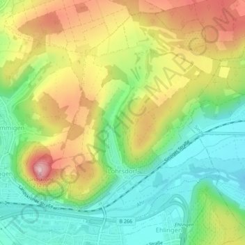
Nom : Carte topographique Lohrsdorf, altitude, relief.
Altitude moyenne : 141 m
Altitude minimum : 64 m
Altitude maximum : 243 m
Faire un don
Équipez-vous pour votre prochaine aventure :
En tant que Partenaire Amazon, ce site perçoit une commission sur les achats éligibles sans surcoût pour vous.
Autres cartes topographiques
Cliquez sur une carte pour visualiser sa topographie, son altitude et son relief.
Landskrone
Deutschland > Rheinland-Pfalz > Landkreis Ahrweiler > Bad Neuenahr-Ahrweiler
Ahrschleife bei Altenahr | An der Teufelsley | Aremberg | Bausenberg | Dachsbusch | Hohe Acht | Hürs-Nück | In der Burwies | Laacher See | Landskrone | Lehrenkopf | Meirother Kopf und Tiefenstein | Mündungsgebiet der Ahr | Nürburg | Quiddelbacher Höhe / Nürburgring | Olbrück | Perler Kopf | Quellgebiet…
Altitude moyenne : 129 m
Neuenahrer Berg
Deutschland > Rheinland-Pfalz > Landkreis Ahrweiler > Bad Neuenahr-Ahrweiler
Altitude moyenne : 213 m