
Carte topographique Impasugong
Carte interactive
Cliquez sur la carte pour afficher l’altitude.
Impasugong
Cool and moist throughout the year due to its high elevation ranging from 500 metres (1,600 ft) to more than 1,000 metres (3,300 ft) above sea level. It is a typhoon-free area ideal for the production of high value crops. Average temperature ranges from 16 to 31 °C (61 to 88 °F) throughout the year.
À propos de cette carte
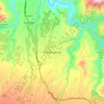
Nom : Carte topographique Impasugong, altitude, relief.
Lieu : Impasugong, Bukidnon, Northern Mindanao, Philippines (8.26605 124.95754 8.34605 125.03754)
Altitude moyenne : 613 m
Altitude minimum : 323 m
Altitude maximum : 993 m