Géolocaliser

Carte topographique Callan

Cliquez sur la carte pour afficher l’altitude.

À propos de cette carte

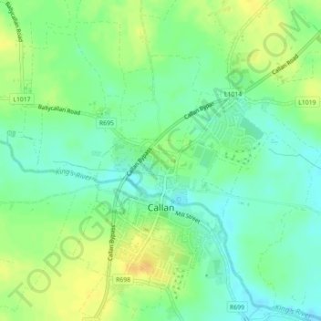
Nom : Carte topographique Callan, altitude, relief.

Lieu : Callan, The Municipal District of Callan — Thomastown, County Kilkenny, Leinster, Ireland (52.53598 -7.40231 52.56097 -7.37434)

Altitude moyenne : 71 m

Altitude minimum : 59 m

Altitude maximum : 85 m

Autres cartes topographiques

Cliquez sur une carte pour visualiser sa topographie, son altitude et son relief.

Hugginstown

Ireland > County Kilkenny

Altitude moyenne : 129 m

Stonyford

Ireland > County Kilkenny

Altitude moyenne : 64 m

Brandon Hill

Ireland > County Kilkenny

Brandon Hill (Irish: Cnoc Bhréanail) is the highest mountain in County Kilkenny, Ireland, with an elevation of 515 m (1,690 ft) and prominence at 448 m (1,470 ft). The South Leinster Way, a long-distance trail, meandering through the Barrow Valley and traverses Brandon Hill. The village of Graiguenamanagh and…

Altitude moyenne : 294 m

Owning

Ireland > County Kilkenny

Altitude moyenne : 97 m

Mount Alto

Ireland > County Kilkenny

Altitude moyenne : 168 m

Ballyfoyle

Ireland > County Kilkenny

Altitude moyenne : 120 m

Finsboro

Ireland > County Kilkenny

Altitude moyenne : 163 m

Windgap

Ireland > County Kilkenny

Altitude moyenne : 149 m

Brandon Hill

Ireland > County Kilkenny

Brandon Hill (Irish: Cnoc Bhréanail) is the highest mountain in County Kilkenny, Ireland, with an elevation of 515 m (1,690 ft) and prominence at 448 m (1,470 ft). The South Leinster Way, a long-distance trail, meandering through the Barrow Valley and traverses Brandon Hill. The village of Graiguenamanagh and…

Altitude moyenne : 294 m

Coon

Ireland > County Kilkenny

Altitude moyenne : 221 m

Walton's Bog

Ireland > County Kilkenny

Altitude moyenne : 66 m

Foyleatalure

Ireland > County Kilkenny

Altitude moyenne : 216 m

Newmarket

Ireland > County Kilkenny > Newmarket

Altitude moyenne : 93 m

Jenkinstown Park

Ireland > County Kilkenny

Altitude moyenne : 77 m

Équipez-vous pour votre prochaine aventure :

Montres GPS outdoor - Montres sport avec suivi GPS, altitude et activités
🧤Gants outdoor - Protection thermique pour mains
🕶️Cordon de Lunettes - Évitez de perdre vos lunettes lors de passages escarpés.
📱Coque Smartphone Robuste - Protection intégrale contre les chocs et la pluie en montagne.
🧊Glacières portables - Conservation aliments en extérieur

En tant que Partenaire Amazon, ce site perçoit une commission sur les achats éligibles sans surcoût pour vous.