
Faire un don
Équipez-vous pour votre prochaine aventure :
En tant que Partenaire Amazon, ce site perçoit une commission sur les achats éligibles sans surcoût pour vous.
Carte topographique Chambersburg
Cliquez sur la carte pour afficher l’altitude.
Faire un don
Équipez-vous pour votre prochaine aventure :
En tant que Partenaire Amazon, ce site perçoit une commission sur les achats éligibles sans surcoût pour vous.
Chambersburg
Chambersburg is served by the Lincoln Highway, U.S. 30, between McConnellsburg and Gettysburg, Pennsylvania. U.S. 11, the Molly Pitcher Highway, passes through it between Shippensburg, Pennsylvania, and Hagerstown, Maryland. Interstate 81 skirts the borough to its east. The town lies approximately midpoint on US Route 30 between Pittsburgh and Philadelphia. The local topography reflects both flatter areas like Philadelphia and mountainous areas like Pittsburgh. Downtown Chambersburg has occasional events such as Food Truck Festival and Apple Fest.
Faire un don
Équipez-vous pour votre prochaine aventure :
En tant que Partenaire Amazon, ce site perçoit une commission sur les achats éligibles sans surcoût pour vous.
À propos de cette carte
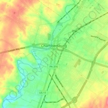
Nom : Carte topographique Chambersburg, altitude, relief.
Lieu : Chambersburg, Franklin County, Pennsylvania, United States (39.90580 -77.68568 39.96065 -77.62369)
Altitude moyenne : 200 m
Altitude minimum : 166 m
Altitude maximum : 254 m
Faire un don
Équipez-vous pour votre prochaine aventure :
En tant que Partenaire Amazon, ce site perçoit une commission sur les achats éligibles sans surcoût pour vous.
Autres cartes topographiques
Cliquez sur une carte pour visualiser sa topographie, son altitude et son relief.
Green Village
United States > Pennsylvania > Franklin County > Greene Township
Altitude moyenne : 207 m
Blue Ridge Summit
United States > Pennsylvania > Franklin County > Washington Township
Pennsylvania Route 16 passes through Blue Ridge Summit, leading east down the mountain to Emmitsburg, Maryland, and west downhill to Waynesboro. The highway elevation at Blue Ridge Summit is 1,330 feet (410 m), compared to elevations of 500 and 700 feet (150 and 210 m) east and west of the mountain,…
Altitude moyenne : 400 m
Faire un don
Équipez-vous pour votre prochaine aventure :
En tant que Partenaire Amazon, ce site perçoit une commission sur les achats éligibles sans surcoût pour vous.
Stoufferstown
United States > Pennsylvania > Franklin County > Guilford Township
Altitude moyenne : 208 m
Caledonia State Park
United States > Pennsylvania > Franklin County > Greene Township
Altitude moyenne : 367 m
Faire un don
Équipez-vous pour votre prochaine aventure :
En tant que Partenaire Amazon, ce site perçoit une commission sur les achats éligibles sans surcoût pour vous.
Metal
United States > Pennsylvania > Franklin County > Metal Township > Metal
Altitude moyenne : 304 m