
Faire un don
Équipez-vous pour votre prochaine aventure :
En tant que Partenaire Amazon, ce site perçoit une commission sur les achats éligibles sans surcoût pour vous.
Carte topographique Brady Lake
Cliquez sur la carte pour afficher l’altitude.
Faire un don
Équipez-vous pour votre prochaine aventure :
En tant que Partenaire Amazon, ce site perçoit une commission sur les achats éligibles sans surcoût pour vous.
À propos de cette carte
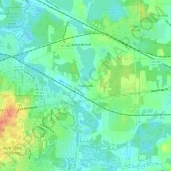
Nom : Carte topographique Brady Lake, altitude, relief.
Altitude moyenne : 328 m
Altitude minimum : 312 m
Altitude maximum : 363 m
Faire un don
Équipez-vous pour votre prochaine aventure :
En tant que Partenaire Amazon, ce site perçoit une commission sur les achats éligibles sans surcoût pour vous.
Autres cartes topographiques
Cliquez sur une carte pour visualiser sa topographie, son altitude et son relief.
Tom S Cooperrider-Kent Bog State Nature Preserve
United States > Ohio > Portage County
Altitude moyenne : 335 m
Faire un don
Équipez-vous pour votre prochaine aventure :
En tant que Partenaire Amazon, ce site perçoit une commission sur les achats éligibles sans surcoût pour vous.
Franklin Township
United States > Ohio > Portage County
Located on the western end of the Glaciated Allegheny Plateau, the topography of Franklin Township includes rolling hills and varied terrain. Lake Rockwell, the main drinking water source for the city of Akron, is in the northeastern part of the township. It was created in 1913 and impounds water from the…
Altitude moyenne : 328 m
Nelson Ledges Quarry Park
United States > Ohio > Portage County > Garrettsville
Altitude moyenne : 306 m
Faire un don
Équipez-vous pour votre prochaine aventure :
En tant que Partenaire Amazon, ce site perçoit une commission sur les achats éligibles sans surcoût pour vous.
Faire un don
Équipez-vous pour votre prochaine aventure :
En tant que Partenaire Amazon, ce site perçoit une commission sur les achats éligibles sans surcoût pour vous.