
Carte topographique Hednesford Hills
Carte interactive
Cliquez sur la carte pour afficher l’altitude.
À propos de cette carte
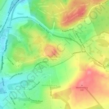
Nom : Carte topographique Hednesford Hills, altitude, relief.
Altitude moyenne : 194 m
Altitude minimum : 154 m
Altitude maximum : 240 m
Autres cartes topographiques
Cliquez sur une carte pour visualiser sa topographie, son altitude et son relief.
Cannock
United Kingdom > England > Staffordshire > Cannock Chase
Cannock, Cannock Chase, Staffordshire, England, WS11 1AW, United Kingdom
Altitude moyenne : 145 m
Brereton
United Kingdom > England > Staffordshire > Cannock Chase
Brereton, Cannock Chase, Staffordshire, England, WS15 1HH, United Kingdom
Altitude moyenne : 106 m
Hednesford
United Kingdom > England > Staffordshire > Cannock Chase
Hednesford, Cannock Chase, Staffordshire, England, United Kingdom
Altitude moyenne : 185 m
Rugeley
United Kingdom > England > Staffordshire > Cannock Chase
Rugeley, Cannock Chase, Staffordshire, England, United Kingdom
Altitude moyenne : 90 m
Cannock Wood
United Kingdom > England > Staffordshire > Cannock Chase
Cannock Wood, Cannock Chase, Staffordshire, England, United Kingdom
Altitude moyenne : 192 m
Norton Canes
United Kingdom > England > Staffordshire > Cannock Chase
Norton Canes, Cannock Chase, Staffordshire, England, WS11 9RE, United Kingdom
Altitude moyenne : 158 m