
Faire un don
Équipez-vous pour votre prochaine aventure :
En tant que Partenaire Amazon, ce site perçoit une commission sur les achats éligibles sans surcoût pour vous.
Carte topographique Gopeshwar
Cliquez sur la carte pour afficher l’altitude.
Faire un don
Équipez-vous pour votre prochaine aventure :
En tant que Partenaire Amazon, ce site perçoit une commission sur les achats éligibles sans surcoût pour vous.
Gopeshwar
Gopeshwar is located at 30°25′N 79°20′E / 30.42°N 79.33°E / 30.42; 79.33. It has an average elevation of 1,450 m (4,760 ft). Gopeshwar is 8.4 km (5.2 mi) away from Chamoli which is located on the banks of Alaknanda river and along NH 58. Gopeshwar is able to captivate any visitor with its mystic charm and pristine beauty. There are multiple snow-capped hills and peaks visible from Gopeshwar.
Faire un don
Équipez-vous pour votre prochaine aventure :
En tant que Partenaire Amazon, ce site perçoit une commission sur les achats éligibles sans surcoût pour vous.
À propos de cette carte
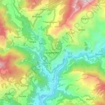
Nom : Carte topographique Gopeshwar, altitude, relief.
Altitude moyenne : 1 566 m
Altitude minimum : 895 m
Altitude maximum : 2 725 m
Faire un don
Équipez-vous pour votre prochaine aventure :
En tant que Partenaire Amazon, ce site perçoit une commission sur les achats éligibles sans surcoût pour vous.
Autres cartes topographiques
Cliquez sur une carte pour visualiser sa topographie, son altitude et son relief.