
Carte topographique Mount Marcy
Carte interactive
Cliquez sur la carte pour afficher l’altitude.
À propos de cette carte
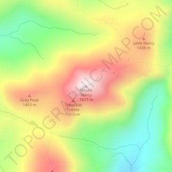
Nom : Carte topographique Mount Marcy, altitude, relief.
Altitude moyenne : 1 289 m
Altitude minimum : 985 m
Altitude maximum : 1 615 m
Mount Marcy (Mohawk: Tewawe’éstha) is the highest point in New York, with an elevation of 5,343.1 feet (1,628.6 m). It is located in the Town of Keene in Essex County. The mountain is in the heart of the Adirondack High Peaks region of the High Peaks Wilderness Area. Its stature and expansive views make it a popular destination for hikers, who crowd its summit in the summer months.
Autres cartes topographiques
Cliquez sur une carte pour visualiser sa topographie, son altitude et son relief.
Keene Valley
United States > New York > Essex County > Town of Keene
Keene Valley, Town of Keene, Essex County, New York, 12943, United States
Altitude moyenne : 459 m
Saint Huberts
United States > New York > Essex County > Town of Keene
Saint Huberts, Town of Keene, Essex County, New York, 12943, United States
Altitude moyenne : 536 m
Glenmore
United States > New York > Essex County > Town of Keene
Glenmore, Town of Keene, Essex County, New York, 12942, United States
Altitude moyenne : 648 m
Giant Mountain
United States > New York > Essex County > Town of Keene
Giant Mountain, Town of Keene, Essex County, New York, United States
Altitude moyenne : 1 060 m
Gothics
United States > New York > Essex County > Town of Keene
Gothics, Town of Keene, Essex County, New York, United States
Altitude moyenne : 1 095 m