
Faire un don
Équipez-vous pour votre prochaine aventure :
En tant que Partenaire Amazon, ce site perçoit une commission sur les achats éligibles sans surcoût pour vous.
Carte topographique Mount Carmel
Cliquez sur la carte pour afficher l’altitude.
Faire un don
Équipez-vous pour votre prochaine aventure :
En tant que Partenaire Amazon, ce site perçoit une commission sur les achats éligibles sans surcoût pour vous.
Mount Carmel
Sawmill operator, Albert Bradford, gave Mount Carmel its name because of its elevation and beautiful setting in the mountains. He decided that it deserved a special name and named it after the holy mountain in Israel. Mount Carmel began as a logging town. Coal was only discovered in 1790 by Isaac Tomlinson. It took twenty-four years until the first shipment of anthracite was shipped from the borough. Mount Carmel Inn was opened in 1812 by Richard Yarnall and was strategically located on the Centre Turnpike (also known as the Reading-Sunbury Road or Old Reading Road) halfway between Pottsville and Danville. During the latter part of 1854, the Philadelphia and Sunbury Railroad was completed from Shamokin to Mt. Carmel, which led to the opening and development of a number of collieries in the region. During the same year, the Locust Mountain Coal and Iron Company commenced making extensive openings and improvements upon their valuable coal lands in the vicinity of Mt. Carmel, building coal breakers for two collieries – the Coal Ridge and Locust Mountain collieries. The township was erected in 1854, formed from part of Coal Township; by 1862 the borough was incorporated within the township.
Faire un don
Équipez-vous pour votre prochaine aventure :
En tant que Partenaire Amazon, ce site perçoit une commission sur les achats éligibles sans surcoût pour vous.
À propos de cette carte
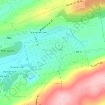
Nom : Carte topographique Mount Carmel, altitude, relief.
Altitude moyenne : 380 m
Altitude minimum : 303 m
Altitude maximum : 503 m
Faire un don
Équipez-vous pour votre prochaine aventure :
En tant que Partenaire Amazon, ce site perçoit une commission sur les achats éligibles sans surcoût pour vous.
Autres cartes topographiques
Cliquez sur une carte pour visualiser sa topographie, son altitude et son relief.
Dalmatia
United States > Pennsylvania > Northumberland County > Lower Mahanoy Township
Altitude moyenne : 172 m
Dalmatia
United States > Pennsylvania > Northumberland County > Lower Mahanoy Township
Altitude moyenne : 172 m
Overlook
United States > Pennsylvania > Northumberland County > Ralpho Township
Altitude moyenne : 261 m
Faire un don
Équipez-vous pour votre prochaine aventure :
En tant que Partenaire Amazon, ce site perçoit une commission sur les achats éligibles sans surcoût pour vous.
Dalmatia
United States > Pennsylvania > Northumberland County > Lower Mahanoy Township
Altitude moyenne : 172 m
Snufftown
United States > Pennsylvania > Northumberland County > Ralpho Township
Altitude moyenne : 215 m
Atlas
United States > Pennsylvania > Northumberland County > Mount Carmel Township
Altitude moyenne : 385 m