
Faire un don
Équipez-vous pour votre prochaine aventure :
En tant que Partenaire Amazon, ce site perçoit une commission sur les achats éligibles sans surcoût pour vous.
Carte topographique La Paz
Cliquez sur la carte pour afficher l’altitude.
Faire un don
Équipez-vous pour votre prochaine aventure :
En tant que Partenaire Amazon, ce site perçoit une commission sur les achats éligibles sans surcoût pour vous.
La Paz
La Paz is located on the Baja California peninsula on the Bay of La Paz, 210 kilometres (130 mi) south of Ciudad Constitución, municipality of Comondú, and 202 kilometres (126 mi) north of Cabo San Lucas, municipality of Los Cabos. It is located 81 kilometres (50 mi) north of the town of Todos Santos. Its geographical coordinates are 24°08′32″ N and parallel 110°18′39″W, it has an altitude of 0 to 27 meters above the sea level. It is one of the three state capitals of Mexico that are on the coast of the sea.
Faire un don
Équipez-vous pour votre prochaine aventure :
En tant que Partenaire Amazon, ce site perçoit une commission sur les achats éligibles sans surcoût pour vous.
À propos de cette carte
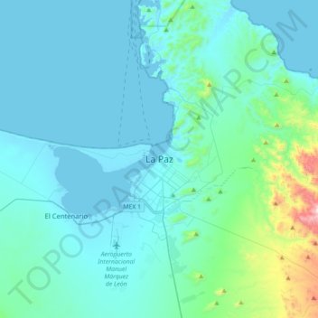
Nom : Carte topographique La Paz, altitude, relief.
Altitude moyenne : 114 m
Altitude minimum : -2 m
Altitude maximum : 1 100 m
Faire un don
Équipez-vous pour votre prochaine aventure :
En tant que Partenaire Amazon, ce site perçoit une commission sur les achats éligibles sans surcoût pour vous.
Autres cartes topographiques
Cliquez sur une carte pour visualiser sa topographie, son altitude et son relief.
Faire un don
Équipez-vous pour votre prochaine aventure :
En tant que Partenaire Amazon, ce site perçoit une commission sur les achats éligibles sans surcoût pour vous.