
Faire un don
Équipez-vous pour votre prochaine aventure :
En tant que Partenaire Amazon, ce site perçoit une commission sur les achats éligibles sans surcoût pour vous.
Carte topographique Mount Kerinci
Cliquez sur la carte pour afficher l’altitude.
Faire un don
Équipez-vous pour votre prochaine aventure :
En tant que Partenaire Amazon, ce site perçoit une commission sur les achats éligibles sans surcoût pour vous.
Mount Kerinci
Mount Kerinci (Kerinci: Gunung Kincai, Minangkabau: Gunuang Kurinci, Indonesian: Gunung Kerinci), also spelled Kerintji, is an active stratovolcano and the highest mountain in Sumatra, Indonesia. At 12,484 ft (3,805 m) above sea level, it provides Sumatra with the fifth-highest maximum elevation of any island in the world. It is surrounded by the lush forest of Kerinci Seblat National Park, home to several endangered species including the Sumatran tiger. Mount Kerinci is ranked 32nd by topographic isolation.
Faire un don
Équipez-vous pour votre prochaine aventure :
En tant que Partenaire Amazon, ce site perçoit une commission sur les achats éligibles sans surcoût pour vous.
À propos de cette carte
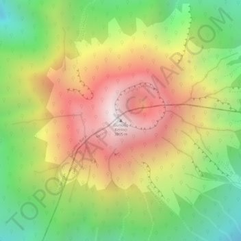
Nom : Carte topographique Mount Kerinci, altitude, relief.
Lieu : Mount Kerinci, Kerinci, Jambi, Sumatra, Indonesia (-1.69723 101.26460 -1.69713 101.26470)
Altitude moyenne : 3 229 m
Altitude minimum : 2 658 m
Altitude maximum : 3 773 m
Faire un don
Équipez-vous pour votre prochaine aventure :
En tant que Partenaire Amazon, ce site perçoit une commission sur les achats éligibles sans surcoût pour vous.
Autres cartes topographiques
Cliquez sur une carte pour visualiser sa topographie, son altitude et son relief.