
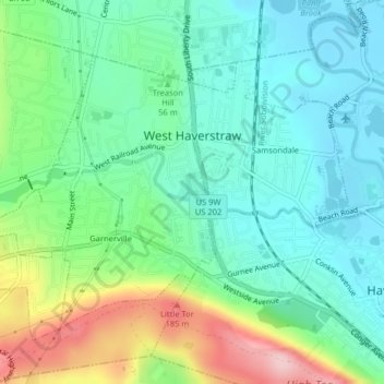
Carte topographique Village of West Haverstraw
Carte interactive
Cliquez sur la carte pour afficher l’altitude.
À propos de cette carte
Nom : Carte topographique Village of West Haverstraw, altitude, relief.
Altitude moyenne : 62 m
Altitude minimum : 0 m
Altitude maximum : 210 m
Autres cartes topographiques
Cliquez sur une carte pour visualiser sa topographie, son altitude et son relief.
Village of Pomona
United States > New York > Rockland County > Town of Haverstraw
Village of Pomona, Town of Haverstraw, Rockland County, New York, United States
Altitude moyenne : 186 m
Thiells
United States > New York > Rockland County > Town of Haverstraw
Thiells, Town of Haverstraw, Rockland County, New York, 10984, United States
Altitude moyenne : 114 m
Village of Haverstraw
United States > New York > Rockland County > Town of Haverstraw
Village of Haverstraw, Town of Haverstraw, Rockland County, New York, 10927, United States
Altitude moyenne : 44 m