
Carte topographique Town of Worcester
Carte interactive
Cliquez sur la carte pour afficher l’altitude.
À propos de cette carte
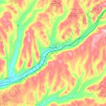
Nom : Carte topographique Town of Worcester, altitude, relief.
Lieu : Town of Worcester, Otsego County, New York, United States (42.50442 -74.78378 42.66185 -74.63084)
Altitude moyenne : 553 m
Altitude minimum : 367 m
Altitude maximum : 740 m
Autres cartes topographiques
Cliquez sur une carte pour visualiser sa topographie, son altitude et son relief.
Town of Hartwick
United States > New York > Otsego County
Town of Hartwick, Otsego County, New York, United States
Altitude moyenne : 489 m
Town of Otego
United States > New York > Otsego County
Town of Otego, Otsego County, New York, 13825, United States
Altitude moyenne : 453 m
Town of Maryland
United States > New York > Otsego County
Town of Maryland, Otsego County, New York, 12155, United States
Altitude moyenne : 490 m
Lena
United States > New York > Otsego County > Town of New Lisbon
Lena, Town of New Lisbon, Otsego County, New York, 13810, United States
Altitude moyenne : 455 m
Village of Cooperstown
United States > New York > Otsego County
Village of Cooperstown, Town of Otsego, Otsego County, New York, United States
Altitude moyenne : 417 m