Géolocaliser

Carte topographique North Bethlehem

Carte interactive

Cliquez sur la carte pour afficher l’altitude.

À propos de cette carte

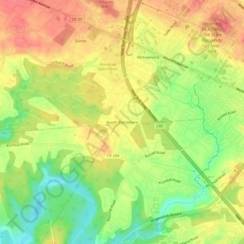
Nom : Carte topographique North Bethlehem, altitude, relief.

Lieu : North Bethlehem, Town of Guilderland, Albany County, New York, 12203, United States (42.65008 -73.86596 42.69008 -73.82596)

Altitude moyenne : 65 m

Altitude minimum : 28 m

Altitude maximum : 93 m

Autres cartes topographiques

Cliquez sur une carte pour visualiser sa topographie, son altitude et son relief.

Westmere

United States > New York > Albany County > Town of Guilderland

Westmere, Town of Guilderland, Albany County, New York, United States

Altitude moyenne : 79 m

Village of Altamont

United States > New York > Albany County > Town of Guilderland

Village of Altamont, Town of Guilderland, Albany County, New York, United States

Altitude moyenne : 158 m

Fort Hunter

United States > New York > Albany County > Town of Guilderland

Fort Hunter, Town of Guilderland, Albany County, New York, 12303, United States

Altitude moyenne : 99 m

Meadowdale

United States > New York > Albany County > Town of Guilderland

Meadowdale, Town of Guilderland, Albany County, New York, 12085, United States

Altitude moyenne : 115 m

Dunnsville

United States > New York > Albany County > Town of Guilderland

Dunnsville, Town of Guilderland, Albany County, New York, 12009, United States

Altitude moyenne : 130 m

Fullers

United States > New York > Albany County > Town of Guilderland

Fullers, Town of Guilderland, Albany County, New York, 12085, United States

Altitude moyenne : 90 m

Hartmans Corners

United States > New York > Albany County > Town of Guilderland

Hartmans Corners, Town of Guilderland, Albany County, New York, 12084, United States

Altitude moyenne : 81 m

Guilderland Center

United States > New York > Albany County > Town of Guilderland

Guilderland Center, Town of Guilderland, Albany County, New York, 12085, United States

Altitude moyenne : 96 m