
Carte topographique Tranquility
Cliquez sur la carte pour afficher l’altitude.
À propos de cette carte
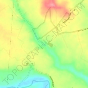
Nom : Carte topographique Tranquility, altitude, relief.
Lieu : Tranquility, Adams County, Ohio, 45679, United States (38.95234 -83.54326 38.97234 -83.52326)
Altitude moyenne : 255 m
Altitude minimum : 206 m
Altitude maximum : 302 m
Autres cartes topographiques
Cliquez sur une carte pour visualiser sa topographie, son altitude et son relief.
Serpent Mound
United States > Ohio > Adams County
The mound is located on the site of a classic astrobleme, an ancient meteorite impact structure. One of the strongest clues to the impact origin of this structure is in the pattern of disruption of sedimentary strata. In the center of the structure, strata have been uplifted several hundred feet, in much the…
Altitude moyenne : 226 m