
Faire un don
Équipez-vous pour votre prochaine aventure :
En tant que Partenaire Amazon, ce site perçoit une commission sur les achats éligibles sans surcoût pour vous.
Carte topographique Debagram
Cliquez sur la carte pour afficher l’altitude.
Faire un don
Équipez-vous pour votre prochaine aventure :
En tant que Partenaire Amazon, ce site perçoit une commission sur les achats éligibles sans surcoût pour vous.
Debagram
Debagram is a part of deltaic alluvial plain of west Bengal formed by river Ganga and its tributaries and distributaries. It has an average elevation of 18 meters. This flat area is characterized by some ponds and low lands. The nearest river of the village is the Bhagirathi. It is about 9 km away from the village centre. Debagram is situated in the north west of Nadia District. Bethuadahari (12 km away), Plassey (12 km), Katwa (18 km) and Tehatta (24 km) is located respectively to the South, North, East and West of Debagram.
Faire un don
Équipez-vous pour votre prochaine aventure :
En tant que Partenaire Amazon, ce site perçoit une commission sur les achats éligibles sans surcoût pour vous.
À propos de cette carte
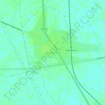
Nom : Carte topographique Debagram, altitude, relief.
Lieu : Debagram, Kaliganj, Nadia, West Bengal, 741137, India (23.66667 88.28006 23.70667 88.32006)
Altitude moyenne : 16 m
Altitude minimum : 11 m
Altitude maximum : 21 m
Faire un don
Équipez-vous pour votre prochaine aventure :
En tant que Partenaire Amazon, ce site perçoit une commission sur les achats éligibles sans surcoût pour vous.