
Faire un don
Équipez-vous pour votre prochaine aventure :
En tant que Partenaire Amazon, ce site perçoit une commission sur les achats éligibles sans surcoût pour vous.
Carte topographique Cheberen
Cliquez sur la carte pour afficher l’altitude.
Faire un don
Équipez-vous pour votre prochaine aventure :
En tant que Partenaire Amazon, ce site perçoit une commission sur les achats éligibles sans surcoût pour vous.
À propos de cette carte
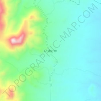
Nom : Carte topographique Cheberen, altitude, relief.
Lieu : Cheberen, Baringo, Kenya (0.21330 35.81330 0.25330 35.85330)
Altitude moyenne : 1 600 m
Altitude minimum : 1 482 m
Altitude maximum : 1 958 m
Faire un don
Équipez-vous pour votre prochaine aventure :
En tant que Partenaire Amazon, ce site perçoit une commission sur les achats éligibles sans surcoût pour vous.
Autres cartes topographiques
Cliquez sur une carte pour visualiser sa topographie, son altitude et son relief.
Lake Baringo
Lake Baringo is, after Lake Turkana, the most northern of the Kenyan Rift Valley lakes, with a surface area of 130 square kilometres (50 sq mi) and an elevation of 970 metres (3,180 ft). The lake is fed by several rivers: the Molo, Perkerra and Ol Arabel. It has no obvious outlet; the waters are assumed to…
Altitude moyenne : 1 053 m
Faire un don
Équipez-vous pour votre prochaine aventure :
En tant que Partenaire Amazon, ce site perçoit une commission sur les achats éligibles sans surcoût pour vous.
Lake Bogoria
There are contradictions regarding its altitude. Unesco's Ramsar gives 963 m (3,159 ft). More precise — and more prudent —, Renaut & Owen 1991 give c. 990 m as of August 1977, but also indicate that the lake's level fluctuates seasonally by 50 to 100 cm; and that it can vary by several meters for short…
Altitude moyenne : 1 318 m
Faire un don
Équipez-vous pour votre prochaine aventure :
En tant que Partenaire Amazon, ce site perçoit une commission sur les achats éligibles sans surcoût pour vous.
Faire un don
Équipez-vous pour votre prochaine aventure :
En tant que Partenaire Amazon, ce site perçoit une commission sur les achats éligibles sans surcoût pour vous.