
Carte topographique Daviess County
Carte interactive
Cliquez sur la carte pour afficher l’altitude.
À propos de cette carte
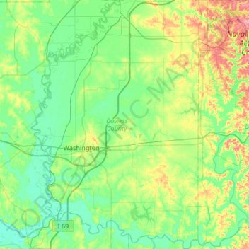
Nom : Carte topographique Daviess County, altitude, relief.
Lieu : Daviess County, Indiana, United States (38.49037 -87.27942 38.90418 -86.90423)
Altitude moyenne : 154 m
Altitude minimum : 123 m
Altitude maximum : 251 m
The terrain of Daviess County is hilly, with its area completely devoted to agriculture or urban development. Its highest elevation (740 ft; 230 m ASL) is a rise one mile (1.6 km) NNE of Farlen. The county is drained by the White River flowing to the southwest, whose two main forks (East White and West White) come together at the county's SW corner. The county's west boundary is defined by the West White River's course and its south boundary is defined by the East White River's course; their confluence defines the county's corner point.
Autres cartes topographiques
Cliquez sur une carte pour visualiser sa topographie, son altitude et son relief.
Indianapolis
United States > Indiana > Indianapolis
Indianapolis, Marion County, Indiana, 46204, United States
Altitude moyenne : 241 m
Halifax Park
United States > Indiana > Hamilton County > Carmel
Halifax Park, Carmel, Hamilton County, Indiana, United States
Altitude moyenne : 274 m
Terre Haute
United States > Indiana > Vigo County
Terre Haute, Vigo County, Indiana, United States
Altitude moyenne : 159 m
Wheatfield
United States > Indiana > Jasper County
Wheatfield, Jasper County, Indiana, United States
Altitude moyenne : 203 m
Wanatah
United States > Indiana > LaPorte County
Wanatah, LaPorte County, Indiana, 46390, United States
Altitude moyenne : 223 m
Fish Creek
United States > Indiana > LaPorte County > Fish Lake
Fish Creek, Fish Lake, LaPorte County, Indiana, United States
Altitude moyenne : 217 m
Elwood
United States > Indiana > Madison County
Elwood, Madison County, Indiana, 46036, United States
Altitude moyenne : 264 m
Carmel
United States > Indiana > Hamilton County
Carmel, Hamilton County, Indiana, United States
Altitude moyenne : 253 m
Angola
United States > Indiana > Steuben County
Angola, Steuben County, Indiana, United States
Altitude moyenne : 315 m
Arlington
United States > Indiana > Rush County
Arlington, Rush County, Indiana, 46104, United States
Altitude moyenne : 280 m
Cicero
United States > Indiana > Hamilton County
Cicero, Hamilton County, Indiana, 46034, United States
Altitude moyenne : 252 m
Larwill
United States > Indiana > Whitley County
Larwill, Whitley County, Indiana, United States
Altitude moyenne : 288 m
Winfield Township
United States > Indiana > Lake County
Winfield Township, Lake County, Indiana, United States
Altitude moyenne : 220 m
Hartleyville
United States > Indiana > Lawrence County
Hartleyville, Lawrence County, Indiana, United States
Altitude moyenne : 185 m
Sellersburg
United States > Indiana > Clark County
Sellersburg, Clark County, Indiana, 47172, United States
Altitude moyenne : 149 m
Union City
United States > Indiana > Randolph County
Union City, Randolph County, Indiana, United States
Altitude moyenne : 333 m
Vanderburgh County
Vanderburgh County, Indiana, United States
Altitude moyenne : 127 m
La Paz
United States > Indiana > Marshall County
La Paz, Marshall County, Indiana, 46537, United States
Altitude moyenne : 261 m
Selma
United States > Indiana > Delaware County
Selma, Delaware County, Indiana, United States
Altitude moyenne : 304 m
Bright
United States > Indiana > Dearborn County
Bright, Miller Township, Dearborn County, Indiana, United States
Altitude moyenne : 222 m
Muncie
United States > Indiana > Delaware County
Muncie, Delaware County, Indiana, United States
Altitude moyenne : 291 m
Beamer
United States > Indiana > Owen County
Beamer, Owen County, Indiana, United States
Altitude moyenne : 206 m
Bristow
United States > Indiana > Perry County
Bristow, Perry County, Indiana, United States
Altitude moyenne : 157 m
Upland
United States > Indiana > Grant County
Upland, Grant County, Indiana, United States
Altitude moyenne : 278 m
Lawrence County
Lawrence County, Indiana, United States
Altitude moyenne : 203 m
Ohio County
Ohio County, Indiana, 47040, United States
Altitude moyenne : 223 m
Parkers Settlement
United States > Indiana > Posey County
Parkers Settlement, Posey County, Indiana, United States
Altitude moyenne : 141 m
Lake James
United States > Indiana > Steuben County
Lake James, Steuben County, Indiana, 46703, United States
Altitude moyenne : 303 m
Vincennes
United States > Indiana > Knox County
Vincennes, Knox County, Indiana, 47591, United States
Altitude moyenne : 134 m
Saint Joseph County
Saint Joseph County, Indiana, United States
Altitude moyenne : 239 m
West Lafayette
United States > Indiana > Tippecanoe County
West Lafayette, Tippecanoe County, Indiana, United States
Altitude moyenne : 192 m
Twin Lakes
United States > Indiana > LaGrange County
Twin Lakes, LaGrange County, Indiana, United States
Altitude moyenne : 262 m
Evansville
United States > Indiana > Vanderburgh County
Evansville, Vanderburgh County, Indiana, United States
Altitude moyenne : 122 m
Henryville
United States > Indiana > Clark County
Henryville, Clark County, Indiana, 47126, United States
Altitude moyenne : 166 m
Amboy
United States > Indiana > Miami County
Amboy, Miami County, Indiana, United States
Altitude moyenne : 251 m
Walkerton
United States > Indiana > Saint Joseph County
Walkerton, Saint Joseph County, Indiana, 46574, United States
Altitude moyenne : 218 m
Johnson County
United States > Indiana > Johnson County
Johnson County, Indiana, United States
Altitude moyenne : 232 m
Lake Seven
United States > Indiana > Lake County > Crown Point
Lake Seven, Crown Point, Lake County, Indiana, United States
Altitude moyenne : 220 m
Bartholomew County
Bartholomew County, Indiana, United States
Altitude moyenne : 209 m
Goshen
United States > Indiana > Scott County
Goshen, Scott County, Indiana, United States
Altitude moyenne : 181 m
Lake Windemere
United States > Indiana > Hamilton County > Carmel
Lake Windemere, Carmel, Hamilton County, Indiana, United States
Altitude moyenne : 273 m