
Faire un don
Équipez-vous pour votre prochaine aventure :
En tant que Partenaire Amazon, ce site perçoit une commission sur les achats éligibles sans surcoût pour vous.
Carte topographique Del City
Cliquez sur la carte pour afficher l’altitude.
Faire un don
Équipez-vous pour votre prochaine aventure :
En tant que Partenaire Amazon, ce site perçoit une commission sur les achats éligibles sans surcoût pour vous.
À propos de cette carte
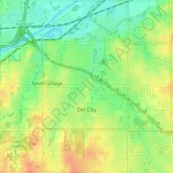
Nom : Carte topographique Del City, altitude, relief.
Lieu : Del City, Oklahoma County, Oklahoma, 73115, United States (35.42074 -97.45951 35.47868 -97.42357)
Altitude moyenne : 369 m
Altitude minimum : 349 m
Altitude maximum : 391 m
Faire un don
Équipez-vous pour votre prochaine aventure :
En tant que Partenaire Amazon, ce site perçoit une commission sur les achats éligibles sans surcoût pour vous.
Autres cartes topographiques
Cliquez sur une carte pour visualiser sa topographie, son altitude et son relief.
Newalla
United States > Oklahoma > Oklahoma County > Oklahoma City
Newalla, with a current elevation of 1,148 feet, is located within the Eastern bounds of Oklahoma County and appears on the Harrah, Oklahoma U.S. Geological Survey Map due to their proximity. Newalla is a geographic area which spans unincorporated Oklahoma County and unincorporated Cleveland County (also…
Altitude moyenne : 343 m
Faire un don
Équipez-vous pour votre prochaine aventure :
En tant que Partenaire Amazon, ce site perçoit une commission sur les achats éligibles sans surcoût pour vous.
Lightning Creek Holding Pond B Dam
United States > Oklahoma > Oklahoma County > Oklahoma City
Altitude moyenne : 386 m
Faire un don
Équipez-vous pour votre prochaine aventure :
En tant que Partenaire Amazon, ce site perçoit une commission sur les achats éligibles sans surcoût pour vous.