Géolocaliser

Carte topographique Swanscombe

Cliquez sur la carte pour afficher l’altitude.

À propos de cette carte
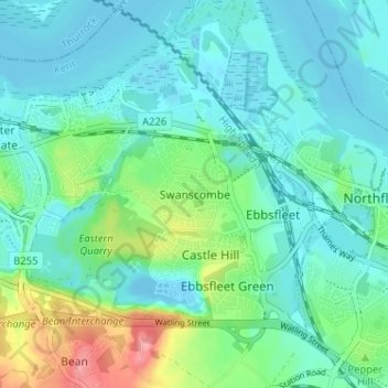
Nom : Carte topographique Swanscombe, altitude, relief.

Lieu : Swanscombe, Dartford, Kent, England, DA10 0JB, United Kingdom (51.42370 0.28657 51.46370 0.32657)

Altitude moyenne : 21 m

Altitude minimum : -7 m

Altitude maximum : 95 m

Autres cartes topographiques

Cliquez sur une carte pour visualiser sa topographie, son altitude et son relief.

Wilmington

United Kingdom > England > Kent > Dartford > Wilmington

Altitude moyenne : 47 m

Craylands Gorge

United Kingdom > England > Kent > Dartford > Swanscombe

Altitude moyenne : 19 m

Bean

United Kingdom > England > Kent > Dartford > Bean

Altitude moyenne : 52 m

Dartford Marshes

United Kingdom > England > Kent > Dartford

Altitude moyenne : 4 m

Darenth

United Kingdom > England > Kent > Dartford > Darenth

Altitude moyenne : 40 m

Wilmington

United Kingdom > England > Kent > Dartford > Wilmington

Altitude moyenne : 47 m

Équipez-vous pour votre prochaine aventure :

🔦Lampes frontales - Éclairage mains libres pour marche nocturne et bivouac
🛠️Outil Multi-fonctions Vélo - Réparations rapides sur les pistes cyclables.
🗡️Couteaux outdoor - Couteaux polyvalents pour randonnée et camping
🧢Bonnets en laine - Protection thermique naturelle
🪑Siège de Randonnée - Chaises ultra-compactes pour vos pauses face au panorama.

En tant que Partenaire Amazon, ce site perçoit une commission sur les achats éligibles sans surcoût pour vous.