
Faire un don
Équipez-vous pour votre prochaine aventure :
En tant que Partenaire Amazon, ce site perçoit une commission sur les achats éligibles sans surcoût pour vous.
Carte topographique Sherman Square
Cliquez sur la carte pour afficher l’altitude.
Faire un don
Équipez-vous pour votre prochaine aventure :
En tant que Partenaire Amazon, ce site perçoit une commission sur les achats éligibles sans surcoût pour vous.
À propos de cette carte
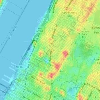
Nom : Carte topographique Sherman Square, altitude, relief.
Altitude moyenne : 22 m
Altitude minimum : -1 m
Altitude maximum : 65 m
Faire un don
Équipez-vous pour votre prochaine aventure :
En tant que Partenaire Amazon, ce site perçoit une commission sur les achats éligibles sans surcoût pour vous.
Autres cartes topographiques
Cliquez sur une carte pour visualiser sa topographie, son altitude et son relief.
Highbridge Park
United States > New York > New York County > New York
The north and south wings respectively contain the women's and men's locker rooms and are nearly identical. Both have nine windows separated by eight brick pilasters. The stone capitals of the pilasters line up with the lintels of the windows. Ramps lead from the extreme ends of each wing. The ground slopes…
Altitude moyenne : 30 m
Fort Tryon Park
United States > New York > New York County > New York
In preparation for converting the land into a city park, Rockefeller hired the Olmsted Brothers firm, particularly Frederick Law Olmsted Jr., son of the designer of Central Park. Olmsted's design capitalized on the topography to reveal sweeping vistas of the Hudson River and the Palisades. Olmsted Jr. was…
Altitude moyenne : 20 m
Faire un don
Équipez-vous pour votre prochaine aventure :
En tant que Partenaire Amazon, ce site perçoit une commission sur les achats éligibles sans surcoût pour vous.