
Faire un don
Équipez-vous pour votre prochaine aventure :
En tant que Partenaire Amazon, ce site perçoit une commission sur les achats éligibles sans surcoût pour vous.
Carte topographique Bel Air
Cliquez sur la carte pour afficher l’altitude.
Faire un don
Équipez-vous pour votre prochaine aventure :
En tant que Partenaire Amazon, ce site perçoit une commission sur les achats éligibles sans surcoût pour vous.
À propos de cette carte
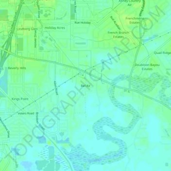
Nom : Carte topographique Bel Air, altitude, relief.
Lieu : Bel Air, St. Tammany Parish, Louisiana, 70461, United States (30.24214 -89.75339 30.28214 -89.71339)
Altitude moyenne : 5 m
Altitude minimum : -2 m
Altitude maximum : 10 m
Faire un don
Équipez-vous pour votre prochaine aventure :
En tant que Partenaire Amazon, ce site perçoit une commission sur les achats éligibles sans surcoût pour vous.
Autres cartes topographiques
Cliquez sur une carte pour visualiser sa topographie, son altitude et son relief.
Mandeville
United States > Louisiana > St. Tammany Parish
Mandeville is located at 30°22′9″N 90°4′41″W / 30.36917°N 90.07806°W / 30.36917; -90.07806 (30.369282, -90.078006), and has an elevation of 7 feet (2.1 m). According to the United States Census Bureau, the city has a total area of 6.8 square miles (17.7 km2), of which 0.12 square miles…
Altitude moyenne : 6 m
Slidell
United States > Louisiana > St. Tammany Parish
Slidell is located at 30°16′45″N 89°46′40″W / 30.27917°N 89.77778°W / 30.27917; -89.77778 (30.279040, -89.777744), and has an elevation of 13 feet (4.0 m). It is in southeastern St. Tammany Parish, located approximately 3 miles (5 km) north of Lake Pontchartrain. The city forms part of the…
Altitude moyenne : 6 m
Faire un don
Équipez-vous pour votre prochaine aventure :
En tant que Partenaire Amazon, ce site perçoit une commission sur les achats éligibles sans surcoût pour vous.
Faire un don
Équipez-vous pour votre prochaine aventure :
En tant que Partenaire Amazon, ce site perçoit une commission sur les achats éligibles sans surcoût pour vous.
Slidell
United States > Louisiana > St. Tammany Parish
Slidell is located at 30°16′45″N 89°46′40″W / 30.27917°N 89.77778°W / 30.27917; -89.77778 (30.279040, -89.777744), and has an elevation of 13 feet (4.0 m). It is in southeastern St. Tammany Parish, located approximately 3 miles (5 km) north of Lake Pontchartrain. The city forms part of the…
Altitude moyenne : 6 m