
Faire un don
Équipez-vous pour votre prochaine aventure :
En tant que Partenaire Amazon, ce site perçoit une commission sur les achats éligibles sans surcoût pour vous.
Carte topographique Thirumudivakkam
Cliquez sur la carte pour afficher l’altitude.
Faire un don
Équipez-vous pour votre prochaine aventure :
En tant que Partenaire Amazon, ce site perçoit une commission sur les achats éligibles sans surcoût pour vous.
À propos de cette carte
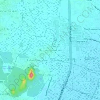
Nom : Carte topographique Thirumudivakkam, altitude, relief.
Altitude moyenne : 20 m
Altitude minimum : 12 m
Altitude maximum : 105 m
Faire un don
Équipez-vous pour votre prochaine aventure :
En tant que Partenaire Amazon, ce site perçoit une commission sur les achats éligibles sans surcoût pour vous.
Autres cartes topographiques
Cliquez sur une carte pour visualiser sa topographie, son altitude et son relief.
Chennai District
Chennai district covers an area of 426 km2 located on the Eastern Coastal Plains of India. It is situated on the northeastern corner of Tamil Nadu along the Coramandel coast, a region bounded by the Bay of Bengal and is surrounded inland by the districts of Tiruvallur, Kanchipuram and Chengalpattu. It lies…
Altitude moyenne : 9 m
Coimbatore District
Apart from the species common to the plains, wild elephants, wild boars leopards, tigers, bison, species of deer, Nilgiri tahr, sloth bear and black-headed oriole can be found. The Anamalai Wildlife Sanctuary 88 km (55 mi) in the Western Ghats at an altitude of 1,400 meters covers an area of 958 km2. More than…
Altitude moyenne : 551 m
Faire un don
Équipez-vous pour votre prochaine aventure :
En tant que Partenaire Amazon, ce site perçoit une commission sur les achats éligibles sans surcoût pour vous.
Faire un don
Équipez-vous pour votre prochaine aventure :
En tant que Partenaire Amazon, ce site perçoit une commission sur les achats éligibles sans surcoût pour vous.
Arcot
India > Tamil Nadu > Arcot
Arcot is located at 12°54′N 79°20′E / 12.9°N 79.33°E / 12.9; 79.33. It has an average elevation of 164 metres (538 ft).
Altitude moyenne : 169 m
Faire un don
Équipez-vous pour votre prochaine aventure :
En tant que Partenaire Amazon, ce site perçoit une commission sur les achats éligibles sans surcoût pour vous.
Kalakkad Mundanthurai Tiger Reserve
India > Tamil Nadu > Ambasamudram
The reserve spans a range of 40 to 1,800 m in elevation. Agasthiyamalai (1681 m.) is in the core zone of the reserve.
Altitude moyenne : 395 m
Faire un don
Équipez-vous pour votre prochaine aventure :
En tant que Partenaire Amazon, ce site perçoit une commission sur les achats éligibles sans surcoût pour vous.
Dharapuram
India > Tamil Nadu > Dharapuram
Dharapuram is located at 10°44′N 77°31′E / 10.73°N 77.52°E / 10.73; 77.52. Dharapuram town is situated along of the bank of Amaravathi River which flows from the south to north. Uppar River and dam, Nallathankal River and dam, Palar join the river Amaravathi. It has an average elevation of 45…
Altitude moyenne : 252 m
Cuddalore
India > Tamil Nadu > Cuddalore
Cuddalore is located at 11°45′N 79°45′E / 11.75°N 79.75°E / 11.75; 79.75. It has an average elevation of 6 m (20 ft). The land is completely flat with large black and alluvial soil inland and coarse sand near the seashore. The sandstone deposits in the town are popular. The Pennayar River runs north of…
Altitude moyenne : 8 m
Faire un don
Équipez-vous pour votre prochaine aventure :
En tant que Partenaire Amazon, ce site perçoit une commission sur les achats éligibles sans surcoût pour vous.
Koothiyarkundu Kanmai
India > Tamil Nadu > Madurai South > Madurai > Thirupparankundram
Altitude moyenne : 138 m
Faire un don
Équipez-vous pour votre prochaine aventure :
En tant que Partenaire Amazon, ce site perçoit une commission sur les achats éligibles sans surcoût pour vous.
Ramanathapuram
India > Tamil Nadu > Ramanathapuram
Ramanathapuram is located at 9°23′N 78°50′E / 9.38°N 78.83°E / 9.38; 78.83. It has an average elevation of 2 metres (6 feet). The nearest towns include Paramakudi, Rameshwaram, Mudukulathur, Kilakarai and Manamadurai.
Altitude moyenne : 7 m
Faire un don
Équipez-vous pour votre prochaine aventure :
En tant que Partenaire Amazon, ce site perçoit une commission sur les achats éligibles sans surcoût pour vous.
Thiruvilliputtur state assembly constituency
India > Tamil Nadu > Srivilliputhur
Altitude moyenne : 321 m
Faire un don
Équipez-vous pour votre prochaine aventure :
En tant que Partenaire Amazon, ce site perçoit une commission sur les achats éligibles sans surcoût pour vous.
Faire un don
Équipez-vous pour votre prochaine aventure :
En tant que Partenaire Amazon, ce site perçoit une commission sur les achats éligibles sans surcoût pour vous.
Faire un don
Équipez-vous pour votre prochaine aventure :
En tant que Partenaire Amazon, ce site perçoit une commission sur les achats éligibles sans surcoût pour vous.
Vellore Fort
India > Tamil Nadu > Vellore > Vellore
It is mentioned that "there is no such fort on the face of earth like the one in Vellore. It had a deep wet ditch (moat) where once 10,000 crocodiles swarmed, waiting to grab every intruder into this impregnable fort. It has huge double walls with bastions projecting irregularly, where two carts can be driven…
Altitude moyenne : 214 m
Faire un don
Équipez-vous pour votre prochaine aventure :
En tant que Partenaire Amazon, ce site perçoit une commission sur les achats éligibles sans surcoût pour vous.
Faire un don
Équipez-vous pour votre prochaine aventure :
En tant que Partenaire Amazon, ce site perçoit une commission sur les achats éligibles sans surcoût pour vous.
Pallapalayam - Kannampalayam Canal
India > Tamil Nadu > Sulur > Kannampalayam
Altitude moyenne : 381 m
Faire un don
Équipez-vous pour votre prochaine aventure :
En tant que Partenaire Amazon, ce site perçoit une commission sur les achats éligibles sans surcoût pour vous.
Faire un don
Équipez-vous pour votre prochaine aventure :
En tant que Partenaire Amazon, ce site perçoit une commission sur les achats éligibles sans surcoût pour vous.
Faire un don
Équipez-vous pour votre prochaine aventure :
En tant que Partenaire Amazon, ce site perçoit une commission sur les achats éligibles sans surcoût pour vous.
Cauvery
India > Tamil Nadu > Sirkali > Alangadu
The Kaveri (also known as Cauvery, the anglicised name) is one of the major Indian rivers flowing through the states of Karnataka and Tamil Nadu. The Kaveri River rises at Talakaveri in the Brahmagiri range in the Western Ghats, Kodagu district of the state of Karnataka, at an elevation of 1,341 m above mean…
Altitude moyenne : 7 m
Faire un don
Équipez-vous pour votre prochaine aventure :
En tant que Partenaire Amazon, ce site perçoit une commission sur les achats éligibles sans surcoût pour vous.
Faire un don
Équipez-vous pour votre prochaine aventure :
En tant que Partenaire Amazon, ce site perçoit une commission sur les achats éligibles sans surcoût pour vous.
Tiruvannamalai
India > Tamil Nadu > Tiruvannamalai
Tiruvannamalai is situated 196 km (122 mi) from the state capital Chennai and 210 km (130 mi) from Bangalore. The height of the Annamalai hill is approximately 2,669 ft (814 m). Tiruvannamalai is located at 12°00′N 79°03′E / 12°N 79.05°E / 12; 79.05. It has an average elevation of 200 metres…
Altitude moyenne : 202 m
Nilgiris
The district has an area of 2,552.50 km2. The district is basically hilly, lying at an elevation of 1,000 to 2,600 metres above MSL, and divided between the Nilgiri plateau and the lower, smaller Wayanad plateau. The district lies at the juncture of the Western Ghats and the Eastern Ghats. Its latitudinal and…
Altitude moyenne : 975 m
Faire un don
Équipez-vous pour votre prochaine aventure :
En tant que Partenaire Amazon, ce site perçoit une commission sur les achats éligibles sans surcoût pour vous.
Faire un don
Équipez-vous pour votre prochaine aventure :
En tant que Partenaire Amazon, ce site perçoit une commission sur les achats éligibles sans surcoût pour vous.
Faire un don
Équipez-vous pour votre prochaine aventure :
En tant que Partenaire Amazon, ce site perçoit une commission sur les achats éligibles sans surcoût pour vous.
Faire un don
Équipez-vous pour votre prochaine aventure :
En tant que Partenaire Amazon, ce site perçoit une commission sur les achats éligibles sans surcoût pour vous.
Salem
Salem is located at 11°40′N 78°08′E / 11.67°N 78.14°E / 11.67; 78.14, at an average elevation of 278 m (912 ft.). The city is surrounded by hills: Nagaramalai on the north, Jarugumalai on the south, Kanjamalai on the west, Godumalai on the east and the Shevaroy Hills on the northeast.…
Altitude moyenne : 400 m
Thiruvallur
The northern taluks of the district like Ponneri, Uttukkottai, Gummidipundi etc. do not have much to offer from the scenic point of view. In the Tiruttani taluk, a number of hillocks are found scattered. The soil of the district is mostly sandy, mixed with soda or other alkali or stony. Rocks found in and near…
Altitude moyenne : 50 m
Faire un don
Équipez-vous pour votre prochaine aventure :
En tant que Partenaire Amazon, ce site perçoit une commission sur les achats éligibles sans surcoût pour vous.
Faire un don
Équipez-vous pour votre prochaine aventure :
En tant que Partenaire Amazon, ce site perçoit une commission sur les achats éligibles sans surcoût pour vous.
Faire un don
Équipez-vous pour votre prochaine aventure :
En tant que Partenaire Amazon, ce site perçoit une commission sur les achats éligibles sans surcoût pour vous.
Faire un don
Équipez-vous pour votre prochaine aventure :
En tant que Partenaire Amazon, ce site perçoit une commission sur les achats éligibles sans surcoût pour vous.