
Faire un don
Équipez-vous pour votre prochaine aventure :
En tant que Partenaire Amazon, ce site perçoit une commission sur les achats éligibles sans surcoût pour vous.
Carte topographique Fairfield County
Cliquez sur la carte pour afficher l’altitude.
Faire un don
Équipez-vous pour votre prochaine aventure :
En tant que Partenaire Amazon, ce site perçoit une commission sur les achats éligibles sans surcoût pour vous.
Fairfield County
The terrain of the county trends from flat near the coast to hilly and higher near its northern extremity. The highest elevation is 1,290 feet (390 m) above sea level along the New York state line south of Branch Hill in the Town of Sherman; the lowest point is sea level itself.
Faire un don
Équipez-vous pour votre prochaine aventure :
En tant que Partenaire Amazon, ce site perçoit une commission sur les achats éligibles sans surcoût pour vous.
À propos de cette carte
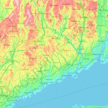
Nom : Carte topographique Fairfield County, altitude, relief.
Altitude moyenne : 108 m
Altitude minimum : -5 m
Altitude maximum : 408 m
Faire un don
Équipez-vous pour votre prochaine aventure :
En tant que Partenaire Amazon, ce site perçoit une commission sur les achats éligibles sans surcoût pour vous.
Autres cartes topographiques
Cliquez sur une carte pour visualiser sa topographie, son altitude et son relief.
Oronoque
United States > Connecticut > Greater Bridgeport Planning Region > Stratford
Altitude moyenne : 37 m
Southport
United States > Connecticut > Greater Bridgeport Planning Region > Fairfield
Altitude moyenne : 11 m
Greenfield Hill
United States > Connecticut > Greater Bridgeport Planning Region > Fairfield
Altitude moyenne : 53 m
Long Hill
United States > Connecticut > Greater Bridgeport Planning Region > Trumbull
Altitude moyenne : 117 m
Faire un don
Équipez-vous pour votre prochaine aventure :
En tant que Partenaire Amazon, ce site perçoit une commission sur les achats éligibles sans surcoût pour vous.
Barn Hill
United States > Connecticut > Greater Bridgeport Planning Region > Monroe
Altitude moyenne : 146 m
Long Hill
United States > Connecticut > Greater Bridgeport Planning Region > Trumbull
Altitude moyenne : 117 m
Powells Hill
United States > Connecticut > Greater Bridgeport Planning Region > Easton
Altitude moyenne : 87 m
Stratfield
United States > Connecticut > Greater Bridgeport Planning Region > Fairfield
Altitude moyenne : 53 m
Faire un don
Équipez-vous pour votre prochaine aventure :
En tant que Partenaire Amazon, ce site perçoit une commission sur les achats éligibles sans surcoût pour vous.
Lordship Beach
United States > Connecticut > Greater Bridgeport Planning Region > Stratford > Lordship
Altitude moyenne : 1 m