
Faire un don
Équipez-vous pour votre prochaine aventure :
En tant que Partenaire Amazon, ce site perçoit une commission sur les achats éligibles sans surcoût pour vous.
Carte topographique Wilkes-Barre
Cliquez sur la carte pour afficher l’altitude.
Faire un don
Équipez-vous pour votre prochaine aventure :
En tant que Partenaire Amazon, ce site perçoit une commission sur les achats éligibles sans surcoût pour vous.
Wilkes-Barre
According to the U.S. Census Bureau, the city has a total area of 7.2 square miles (19 km2), of which 6.8 square miles (18 km2) is land and 0.3 square miles (0.78 km2), or 4.60%, is water. The city is bordered by the Susquehanna River to the west. Most of Downtown is located on a wide floodplain. Floodwalls were constructed to protect a large percentage of the city. The elevation of the downtown area is about 550 feet (170 m) above sea level. As you travel inland, away from the river, the elevation rises. Wilkes-Barre Mountain is a physical barrier southeast of the city.
Faire un don
Équipez-vous pour votre prochaine aventure :
En tant que Partenaire Amazon, ce site perçoit une commission sur les achats éligibles sans surcoût pour vous.
À propos de cette carte
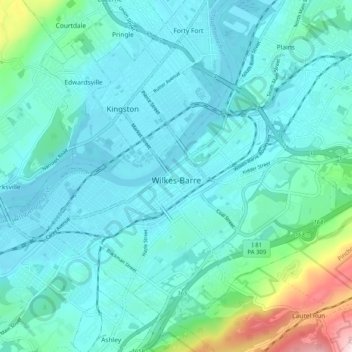
Nom : Carte topographique Wilkes-Barre, altitude, relief.
Lieu : Wilkes-Barre, Luzerne County, Pennsylvania, United States (41.22193 -75.92814 41.27292 -75.82685)
Altitude moyenne : 218 m
Altitude minimum : 154 m
Altitude maximum : 574 m
Faire un don
Équipez-vous pour votre prochaine aventure :
En tant que Partenaire Amazon, ce site perçoit une commission sur les achats éligibles sans surcoût pour vous.
Autres cartes topographiques
Cliquez sur une carte pour visualiser sa topographie, son altitude et son relief.
Ricketts Glen State Park
United States > Pennsylvania > Luzerne County > Fairmount Township
The state's original plans for the new park included building an inn, an 18-hole golf course and country club, and a winter sports complex for skiing, ice boating, and tobogganing, as well as a beach with bathing facilities, cabins, and a tent camping area. Only the last three were actually built, all south of…
Altitude moyenne : 588 m
Faire un don
Équipez-vous pour votre prochaine aventure :
En tant que Partenaire Amazon, ce site perçoit une commission sur les achats éligibles sans surcoût pour vous.
Wapwallopen
United States > Pennsylvania > Luzerne County > Conyngham Township
Altitude moyenne : 223 m
Faire un don
Équipez-vous pour votre prochaine aventure :
En tant que Partenaire Amazon, ce site perçoit une commission sur les achats éligibles sans surcoût pour vous.
Town Hill
United States > Pennsylvania > Luzerne County > Huntington Township
Altitude moyenne : 281 m
Roaring Brook
United States > Pennsylvania > Luzerne County > Hunlock Township
Altitude moyenne : 337 m
Faire un don
Équipez-vous pour votre prochaine aventure :
En tant que Partenaire Amazon, ce site perçoit une commission sur les achats éligibles sans surcoût pour vous.
Fern Glen
United States > Pennsylvania > Luzerne County > Black Creek Township
Altitude moyenne : 391 m
Faire un don
Équipez-vous pour votre prochaine aventure :
En tant que Partenaire Amazon, ce site perçoit une commission sur les achats éligibles sans surcoût pour vous.
Faire un don
Équipez-vous pour votre prochaine aventure :
En tant que Partenaire Amazon, ce site perçoit une commission sur les achats éligibles sans surcoût pour vous.
Liewellyn Corners
United States > Pennsylvania > Luzerne County > Bear Creek Township
Altitude moyenne : 449 m
Wapwallopen
United States > Pennsylvania > Luzerne County > Conyngham Township
Altitude moyenne : 223 m
Faire un don
Équipez-vous pour votre prochaine aventure :
En tant que Partenaire Amazon, ce site perçoit une commission sur les achats éligibles sans surcoût pour vous.
Glen Summit
United States > Pennsylvania > Luzerne County > Fairview Township
Altitude moyenne : 539 m
Faire un don
Équipez-vous pour votre prochaine aventure :
En tant que Partenaire Amazon, ce site perçoit une commission sur les achats éligibles sans surcoût pour vous.
Hunlock Creek
United States > Pennsylvania > Luzerne County > Hunlock Township > Hunlock
Altitude moyenne : 276 m
Huntington Mills
United States > Pennsylvania > Luzerne County > Huntington Township
Altitude moyenne : 289 m
Faire un don
Équipez-vous pour votre prochaine aventure :
En tant que Partenaire Amazon, ce site perçoit une commission sur les achats éligibles sans surcoût pour vous.
Faire un don
Équipez-vous pour votre prochaine aventure :
En tant que Partenaire Amazon, ce site perçoit une commission sur les achats éligibles sans surcoût pour vous.
Fern Glen
United States > Pennsylvania > Luzerne County > Black Creek Township
Altitude moyenne : 391 m
South Pond Dam
United States > Pennsylvania > Luzerne County > Hanover Township
Altitude moyenne : 204 m
Faire un don
Équipez-vous pour votre prochaine aventure :
En tant que Partenaire Amazon, ce site perçoit une commission sur les achats éligibles sans surcoût pour vous.